Pampas (Huancavelica)
| pampas | ||
|---|---|---|
|
|
||
| Coordinates | 12 ° 24 ′ S , 74 ° 52 ′ W | |
| Basic data | ||
| Country | Peru | |
| Huancavelica | ||
| province | Tayacaja | |
| ISO 3166-2 | PE-HUV | |
| District | pampas | |
| height | 3276 m | |
| Residents | 7839 (2017) | |
| founding | June 21, 1825 | |
|
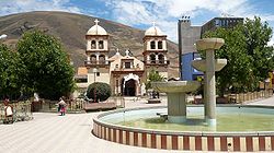
Plaza de Armas
|
||
Pampas is a city in the Huancavelica region of central Peru . The city is the seat of the provincial administration of Tayacaja and is located in the Pampas district . In the 2017 census, the population was 7,839, 10 years earlier it was 6,027.
Geographical location
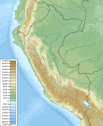
The city is located 240 km east-southeast of the state capital Lima . It is located in a high valley of the Central Cordillera , which is traversed by the Río Upamayo in an easterly direction to the Río Mantaro . The city lies at an altitude of 3276 m . A partly asphalt road connects the place with the nearest large cities Huancayo (in the north) and Ayacucho (in the south).
climate
The city is located in the Quechua High Zone. There is a temperate climate, semi-arid summers with moderate rainfall. Average temperatures vary between 10 and 13 ° C. In the months of June to August, the average minimum temperatures reach values close to freezing point.
Individual evidence
- ↑ PERU: Region Huancavelica - Places . www.citypopulation.de. Retrieved December 12, 2019.


