Panueler's head
| Panueler's head | ||
|---|---|---|
|
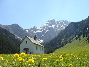
View from the Nenzing sky to the Panüeler head |
||
| height | 2859 m above sea level A. | |
| location | Vorarlberg , Austria | |
| Mountains | Rätikon | |
| Dominance | 2.4 km → Schesaplana | |
| Notch height | 146 m ↓ Schafloch | |
| Coordinates | 47 ° 4 '1 " N , 9 ° 40' 47" E | |
|
|
||
| rock | Main dolomite , Kössen formation | |
| Age of the rock | Upper Carnium - Hettangium | |
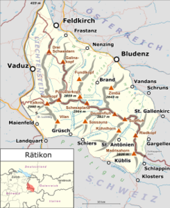
The Panüeler Kopf (also written Panüelerkopf or Panüler head , popularly also simply Panuler ) is at 2859 m above sea level the second highest mountain in the Rätikon , a mountain range on the border between Vorarlberg and Switzerland . The Panüeler head itself is entirely in Vorarlberg. It borders the western side of the Brandner Glacier and can be climbed in just over an hour from the Mannheimer Hütte at 2679 m above sea level . To the north, the Panüeler Kopf falls in a mighty rock face to the Nenzing sky .
A route marked with blue and white markings is available for the ascent, but requires some climbing skill, surefootedness and a head for heights. The Panüelerkopf can be reached from the Nenzinger Himmel via the legendary and spectacular Spusagang and the Strausssteig in about three and a half hours of walking. Once at the top you have a wonderful view to the northeast towards Brand and to the north towards the Gamperdonatal .
A beautiful two-day mountain tour from Brand is the circular hike over the Schesaplana and the Panüeler Kopf back to Brand. First you take the cable car to the Lünersee , from there you continue over the Totalphütte to the Schesaplana (2964 m), the highest mountain in the Rätikon. The descent takes place over the Brandner Glacier to the Mannheimer Hütte. The next day the Panüeler Kopf can be crossed, the descent is via the Leibersteig or the Strausssteig, down to the Oberzalimhütte and further back to Brand.
Day 1: Without cable car approx. 1300 vertical meters.
Day 2: Ascent approx. 250 vertical meters, descent approx. 1700 vertical meters
Web links
literature
- Manfred Hunziker: Ringelspitz / Arosa / Rätikon , Alpine Touren / Bündner Alpen , Verlag des SAC 2010, ISBN 978-3-85902-313-0 , p. 538.

