Santo André (Sao Paulo)
| Santo André | ||
|---|---|---|
|
Coordinates: 23 ° 40 ′ S , 46 ° 32 ′ W Santo André on the map of São Paulo
|
||
| Basic data | ||
| Country | Brazil | |
| State | São Paulo | |
| City foundation | 1553 | |
| Residents | 654,354 (2010) | |
| City insignia | ||
| Detailed data | ||
| surface | 174.840 km 2 | |
| Population density | 3.743 inhabitants / km 2 | |
| height | 760 m | |
| Time zone | UTC −3 | |
| Website | ||
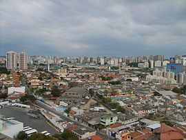
| Panorama of Santo André | ||
Santo André is a city in the Brazilian state of São Paulo , about 18 km from São Paulo city . In 2010 there were 654,354 people in Santo André on 175 km². Santo André belongs to the ABC Paulista , the industrial district in the southeast of São Paulo.
Districts
Sports
The local soccer club EC Santo André plays in 2010 in the Série B , the second highest division in Brazil. In 2004 he surprisingly won the Brazilian Cup .
Town twinning
sons and daughters of the town
- Cacau (Jeronimo Barreto) (* 1981), former soccer player (including VfB Stuttgart and player of the German national soccer team )
- Edson Cordeiro (* 1967), singer and countertenor
- Jair da Costa (* 1940), football player
- Sandro Dias (* 1975), skateboarder
- Antônio Augusto Dias Duarte (* 1948), Roman Catholic clergyman, auxiliary bishop in Rio de Janeiro
- Rodrigo Fabri (* 1976), football player
- Daniele Hypólito (* 1984), artistic gymnast
- Diego Hypólito (* 1986), artistic gymnast
- Luis Sacilotto (1924–2003), painter and sculptor
- Leandro Ricardo Vieira (* 1979), football player
Web links
- Official Website (Portuguese)


