Parobé
| Parobé | ||
|---|---|---|
|
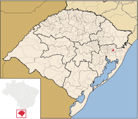
Coordinates: 29 ° 38 ′ S , 50 ° 50 ′ W Parobé on the map of Rio Grande do Sul
|
||
| Basic data | ||
| Country | Brazil | |
| State | Rio Grande do Sul | |
| City foundation | May 1, 1982 | |
| Residents | 51.502 (IBGE / 2010) | |
| City insignia | ||
| Detailed data | ||
| surface | 109.026 km 2 | |
| Population density | 474.03 inhabitants / km 2 | |
| height | 133 m | |
| Waters | Rio dos Sinos | |
| Time zone | UTC −3 | |
| City Presidency | Maria Eliane Nunes (MDB, 2019-2020) | |
| Location of Parobé in Rio Grande do Sul | ||
Parobé is a city with 57,660 inhabitants (as of 2018) in the state of Rio Grande do Sul in southern Brazil . It is located about 80 km northeast of Porto Alegre . Neighboring are the places Igrejinha , Taquara , Araricá and Nova Hartz . Originally Parobé was part of the municipalities of Sapiranga and Taquara.
Web links
Commons : Parobé - collection of images, videos and audio files
- Citizen portal of the Prefeitura Municipal
- Parobé - panorama. In: cidades.ibge.gov.br. IBGE (Brazilian Portuguese, updated statistics).


