Taquara
| Taquara | ||
|---|---|---|
|
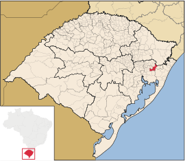
Coordinates: 29 ° 39 ′ S , 50 ° 47 ′ W Taquara on the map of Rio Grande do Sul
|
||
| Basic data | ||
| Country | Brazil | |
| State | Rio Grande do Sul | |
| City foundation | April 17, 1886 | |
| Residents | 54,643 (IBGE / 2010) | |
| City insignia | ||
| Detailed data | ||
| surface | 457.13 km 2 | |
| Population density | 120 people / km 2 | |
| height | 57 m | |
| Waters | Rio dos Sinos | |
| Time zone | UTC −3 | |
| Website | ||
| Location of Taquara in Rio Grande do Sul | ||
Taquara is a city with 57,466 inhabitants (estimate as of 2019) in the state of Rio Grande do Sul in southern Brazil . It is located about 75 km northeast of Porto Alegre . Neighboring are the towns of Araricá , Glorinha , Gravataí , Igrejinha , Novo Hamburgo , Parobé , Rolante , Santo Antônio da Patrulha , Sapiranga , São Francisco de Paula and Três Coroas .
Taquara is a center primarily for German immigrants.
Place name
The city's name comes from Taquara , a bamboo-like plant that lined the banks of the Rio dos Sinos at the time of settlement .
sons and daughters of the town
- Rodolpho von Ihering (1883-1939), biologist
- Adalberto Pereira dos Santos (1905–1984), general and politician, 1974–79 Vice-President of the military dictatorship
- Otto Bumbel (1914–1998), soccer coach (made Atlético Madrid champions)
- Osvaldo Brandão (1916–1989), football coach, a. a. National coach of Brazil
- Sonia Ebling de Kermoal (1918–2006), sculptor and university teacher
- Sérgio Moacir Torres Nunes (1926–2007), football player and coach
- Tasso Bangel (* 1931), composer
- Menalton João Braff (* 1938), writer
- Romano Rodrigues (* 1987), football player
Web links
- City website (Portuguese)
- IBGE to Taquara. (Brazilian Portuguese, updated statistics).


