
Passau Hut
| Passauer Hütte DAV refuge category I |
||
|---|---|---|
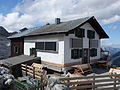
 Passauer Hütte with a new extension from 2012 (front left) and 2015 (front center) |
||
| location | over the Mittagsscharte; Salzburg ; Valley location: Weißbach near Lofer | |
| Mountain range | Leoganger Steinberge | |
| Geographical location: | 47 ° 28 ′ 27 " N , 12 ° 45 ′ 2" E | |
| Altitude | 2051 m above sea level A. | |
|
||
| owner | DAV - Passau section | |
| Construction type | Refuge | |
| Usual opening times | Beginning of June to beginning of October | |
| accommodation | 0 beds, 37 camps , 10 emergency camps | |
| Winter room | 6 bearings | |
| Web link | Site of the hut | |
| Hut directory | ÖAV DAV | |


The Passauer Hütte is an alpine club hut of the Passau section of the German Alpine Club and is located west of the Mittagsscharte in the Leoganger Steinberge in the west of the Austrian state of Salzburg in the municipality of Weißbach bei Lofer at an altitude of 2051 m above sea level. A. The area belongs to the Grub forest district in the Fallck district of the Saalforste .
history
The Passauer Hütte was built as a simple refuge from 1891–1892 by the German and Austrian Alpine Club , Passau section . After being destroyed by fire in 1946, it was rebuilt in its current form from 1954 to 1956. In 1978 the hut was renovated and in 2002 it was given a new sun terrace. In 2012, an annex was added and modernized, including a power plant. The hut was renovated in 2014, and another extension was added in 2015.

Passauer Hut (approx. 1894)
Passau Hut (2014)


Arrival and access
The ascent to the hut is easy to reach by public transport; especially from the Leogang Valley, where there are two conveniently located S-Bahn stops on the main Innsbruck – Salzburg route .
- From the Leogang valley
- From the Leogang-Steinberge train station in 3 hours on the Hüttenweg (620) via the Hochtor (wire ropes)
- Slightly shorter from Ullach
- From the Leogang train station , meets the Hüttenweg in the Birnbachtal
- From the Leogang-Steinberge train station via the Lettlkaser in 4 hours
- From Mitterbrand about ½ hour shorter.
- From the Leogang-Steinberge train station in 3 hours on the Hüttenweg (620) via the Hochtor (wire ropes)
- From the Saalachtal
- from Weißbach in 4½ hours
- from Diesbach in 4 hours
- with the hiking taxi from Weißbach the ascent is shortened to 2 hours
Tour possibilities
-
Birnhorn ( 2634 m )
- over Hochgrub and Kuchelnieder in 2 hours (climbing grade I, secured) or
- via Melkerloch and Hofersteig in 2 hours (I, unsecured).
- Hochzint ( 2251 m ) in 40 minutes
- Kuchelhorn ( 2507 m ) in 1½ hours
- Dürrkarhorn ( 2287 m ) in 1½ hours
- Great Rothorn ( 2442 m ) in 3 hours
- Schaleithörner ( 2461 m ) in 3 hours
- Tricorn horns ( 2484 m ) in 4 hours
- Via ferrata Leoganger Nord and Leoganger Süd on the Fahnenköpfl ( 2148 m , difficult)
- Views from the Passauer Hütte
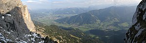
View in southeast direction of the Radstädter Tauern , Ankogel and Goldberg groups , in the Saalfelden and Leogang valley

View in northeast direction of the Hochkaltergebirge and Watzmannstock


literature
Web links
- official homepage
- Passauer Hütte in the Historical Alpine Archive of the Alpine Clubs in Germany, Austria and South Tyrol (temporarily offline)
Individual evidence
- ↑ A hut goes into hibernation ... ( Memento of the original from November 2, 2016 in the Internet Archive ) Info: The archive link was automatically inserted and not yet checked. Please check the original and archive link according to the instructions and then remove this notice. , accessed February 1, 2012
- ↑ Hut info , accessed on September 10, 2015