Patos de Minas
| Município de Patos de Minas "Capital Nacional do Milho"
Patos de Minas
"Patos", "PDM" |
|||
|---|---|---|---|
|
Santo Antônio Cathedral, Praça Getúlio Vargas, left: bronze bust of Olegário Maciel
|
|||
|
|
|||
| Coordinates | 18 ° 36 ′ S , 46 ° 31 ′ W | ||
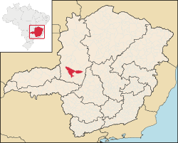
 Location and area outline of the municipality in the state of Minas Gerais Location and area outline of the municipality in the state of Minas Gerais
|
|||
| Symbols | |||
|
|||
| Basic data | |||
| Country | Brazil | ||
| State | Minas Gerais | ||
| ISO 3166-2 | BR-MG | ||
| Região intermediária | Patos de Minas (since 2017) | ||
| Região imediata | Patos de Minas (since 2017) | ||
| height | 856 m | ||
| climate | tropical mountain climate, Cwa / Aw | ||
| surface | 3,190.2 km² | ||
| Residents | 138,710 (2010) | ||
| density | 43.5 Ew. / km² | ||
| estimate | 150,833 (July 1, 2018) | ||
| Parish code | IBGE : 3148004 | ||
| Post Code | 38700-000 to 38717-000 | ||
| Telephone code | (+55) 34 | ||
| Website | www.patosdeminas.mg.gov.br/home/ (Brazilian Portuguese) | ||
| politics | |||
| City Prefect | José Eustáquio Rodrigues Alves (2017–2020) | ||
| Political party | Democratas (DEM) | ||
| Culture | |||
| Patron saint | Anthony of Padua (Santo Antônio) | ||
| economy | |||
| GDP | 3,816,282 thousand R $ 25,654 R $ per person (2015) |
||
| HDI | 0.765 (2010) | ||
Patos de Minas , officially Portuguese Município de Patos de Minas , German ducks of Minas , is a city with a large municipality in the Brazilian state of Minas Gerais . It is located 415 km from the capital Belo Horizonte and lies on the Rio Paranaíba at about 800 meters above sea level.
The city had an estimated 150,833 inhabitants in 2018 (according to the 2010 census: 138,710 inhabitants), who are called Patenser (Portuguese patenses ). The territory of the municipality extends over 3190 km² (2017), the urban area about 22.7 km².
history
The colonization of today's urban area probably began in the middle of the 18th century. The founding of the Vila took place in 1868, the emancipation as a city on May 24, 1892.
Economy and Infrastructure
Patos de Minas is known nationwide for its maize production; the city is considered the corn capital of Brazil.
A 2001 study by Veja magazine found that Patos de Minas ranks 5th among 5000 cities in terms of socio-economic development between 1970 and 1996. 99% of the city's streets are paved and have public street lighting. 97% of the population are supplied with clean water.
There is a public university in Patos de Minas. There is a regional airport 6.5 km from the city with daily flights to Belo Horizonte and Uberaba .
Diocese of Patos de Minas
On April 5, 1955, the Roman Catholic diocese of Patos de Minas was established. The construction of the cathedral, planned as a parish church and consecrated to St. Anthony of Padua , began in 1934; but it was not completed until 1954. Almost 80 percent of the population are Catholic.
literature
- Oliveira Mello: Patos de Minas, meu bem querer. 3. Edition. SEMED, Patos de Minas 2008.
- Ludmila Ítala Soares Silva: O Plano Diretor Urbano de Patos de Minas. MG: Uma avaliação geográfica-cartográfica. Universidade de Brasília, Instituto de Ciências Humanas, Departamento de Geografia. Brasília, 2015. ( Online , PDF, 4.8 MB, Brazilian Portuguese)
Web links
- City Prefecture website , Prefeitura Municipal (Brazilian Portuguese)
- City Council website , Câmara Municipal (Brazilian Portuguese)
Individual evidence
- ↑ Climate Patos de Minas: Weather, average temperature, weather forecast for Patos de Minas. In: climate-data.org. de.climate-data.org, accessed on November 15, 2018 .
- ↑ a b IBGE : Patos de Minas - Panorama. In: cidades.ibge.gov.br. Retrieved November 15, 2018 (Brazilian Portuguese).
- ↑ José Eustaquio 25 (Prefeito). In: com.br. Eleições 2016, accessed November 15, 2018 (Brazilian Portuguese).
- ↑ IBGE : Estimativas da população residente no Brasil e unidades da federação com data de referência em 1 ° de julho de 2018. (PDF; 2.6 MB) In: ibge.gov.br. 2018, accessed November 15, 2018 (Brazilian Portuguese).


