Paul Roux
| Paul Roux | ||
|---|---|---|
|
|
||
| Coordinates | 28 ° 18 ′ 0 ″ S , 27 ° 57 ′ 0 ″ E | |
| Basic data | ||
| Country | South Africa | |
| free State | ||
| District | Thabo Mofutsanyana | |
| ISO 3166-2 | ZA-FS | |
| local community | Dihlabeng | |
| surface | 5.3 km² | |
| Residents | 437 (2011) | |
| density | 82.1 Ew. / km² | |
| founding | 1909 | |
|
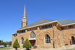
Dutch Reformed Church in Paul Roux
|
||
Paul Roux is a city in the province of Free State , South Africa . It is about 250 kilometers northeast of Bloemfontein and 40 kilometers west of Bethlehem . In 2011 it had 437 inhabitants. The neighboring township of Fateng Tse Ntsho had 5715 inhabitants.
history
The city was founded in 1909 by Paul Hendrik Roux , Reverend of the Dutch Reformed Church of South Africa , on the Palmietfontein farm .
A monument on the farm Tevrede reminiscent of the children of the Boers , during the Great Trek to measles died. During the Second Boer War (1899 to 1902) the British occupied the Witnek farm and set up a hospital in the house. One of the legacies of apartheid is the township of Fateng-Tse-Ntsho, east of the city .
Economy and Transport
Agriculture is the predominant industry. The poplars growing around Paul Roux are processed in the match industry.
Paul Roux also offers some tourist destinations. So you can visit cave paintings of the San . On the farm Uniondale were dinosaur footprints found. The sandstone buildings are characteristic of Paul Roux , especially the school from 1912 and the Dutch Reformed Church.
Paul Roux has a road connection to Durban and Bloemfontein as well as Johannesburg via the national road N5 .
Personalities
- Pieter Willem Botha (1916–2006), Prime Minister and President of South Africa, born in Paul Roux
Web links
- Information about Paul Roux (English)
Individual evidence
- ^ Paul Roux , accessed July 8, 2017
- ^ Fateng Tse Ntsho , accessed July 8, 2017

