Petite Rhue
| Petite Rhue | ||
|
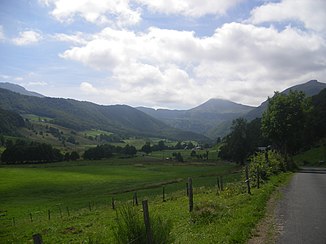
Petite Rhue valley with the Puy Mary in the background |
||
| Data | ||
| Water code | FR : P05-0400 | |
| location | France , Auvergne-Rhône-Alpes region | |
| River system | Dordogne | |
| Drain over | Rhue → Dordogne → Atlantic Ocean | |
| source | in the municipality of Le Claux 45 ° 7 ′ 23 ″ N , 2 ° 40 ′ 25 ″ E |
|
| Source height | approx. 1480 m | |
| muzzle | near Coindre , in the municipality of Saint-Amandin , in the Rhue Coordinates: 45 ° 21 ′ 8 ″ N , 2 ° 39 ′ 49 ″ E 45 ° 21 ′ 8 ″ N , 2 ° 39 ′ 49 ″ E |
|
| Mouth height | 576 m | |
| Height difference | approx. 904 m | |
| Bottom slope | approx. 24 ‰ | |
| length | 37 km | |
| Catchment area | 195 km² | |
| Left tributaries | Petite Rhue d'Eybes , Véronne | |
The Petite Rhue (sometimes called Rhue de Cheylade ) is a river in France in the Cantal department in the Auvergne-Rhône-Alpes region .
It rises in the municipality of Le Claux , on the eastern flank of the Puy de la Tourte , in the Volcans d'Auvergne Regional Nature Park . The river runs in a northerly direction and flows after 37 kilometers at Coindre , municipality of Saint-Amandin , as a left tributary into the Rhue , which is often also called Grande Rhue in the mouth area to distinguish it.
Places on the river
Attractions
- Cascade du Sartre waterfall between Le Claux and Cheylade
- Barajol Railway Viaduct
