Pfalzheim
|
Pfalzheim
community Temnitzquell
Coordinates: 53 ° 2 ′ 0 ″ N , 12 ° 40 ′ 9 ″ E
|
|
|---|---|
| Height : | 69 m above sea level NHN |
| Residents : | 60 (Dec 31, 2006) |
| Incorporation : | January 1, 1960 |
| Incorporated into: | Rägelin |
| Postal code : | 16818 |
| Area code : | 033924 |
|
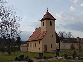
Pfalzheim village church
|
|
Pfalzheim is a residential area belonging to the district of Rägelin in the municipality of Temnitzquell in the Ostprignitz-Ruppin district in Brandenburg . The place belongs to the Temnitz office and was an independent municipality until it was incorporated into Rägelin on January 1, 1960.
location
Pfalzheim is located in the Ruppiner Land , around 15 kilometers as the crow flies northwest of Neuruppin , immediately south of the source of the Temnitz river . The place is surrounded by forest on all sides. Surrounding villages are Neuglienicke and Gühlen-Glienicke in the northeast, Steinberge in the east, Frankendorf in the southeast, Rägelin in the southwest and Rossow in the west. Sielmann's natural landscape, the Ruppiner Heide, is located near Pfalzheim .
A local road leads from Pfalzheim to the neighboring town of Rägelin. Landesstraße 18 is three kilometers from Pfalzheim.
history
Pfalzheim was founded in 1747 on the deserted field mark of the village of Wüsten-Rägelin by the appointment of colonists from the Palatinate, which explains the place name. Wüsten-Rägelin, on the other hand, was first mentioned in a document in 1238 and fell in ruins after 1324. The eight families that were settled in Pfalzheim each received three Hufen land and ten acres of meadow for cultivation. In 1798 Pfalzheim had 67 inhabitants, of whom twelve were men, 13 women and 33 children and nine were servants. As part of the Alt Ruppin office , Pfalzheim belonged to the Ruppin district and was thus part of the Mark Brandenburg until 1815 and then the Prussian province of Brandenburg . In 1872 the Alt Ruppin office was dissolved. The village church was built in 1912, before the Pfalzheim church belonged to Storbeck and Rägelin .
From 1952 the community Pfalzheim belonged to the district Neuruppin in the GDR district Potsdam . On January 1, 1960, the place was incorporated into Rägelin. After reunification , Pfalzheim was still in the Neuruppin district for three years and then joined the Ostprignitz-Ruppin district . The municipality of Rägelin became a district of the newly founded municipality of Temnitzquell on December 31, 1997 and Pfalzheim was downgraded to a residential area.
Population development
|
|
|
Territory of the respective year
Web links
Individual evidence
- ↑ Reinhard E. Fischer : The place names of the states of Brandenburg and Berlin. Age - origin - meaning. be.bra Wissenschaft Verlag, Berlin 2005, p. 130.
- ^ Friedrich Wilhelm August Bratring: The Graffschaft Ruppin in historical, static and geographical terms. Gottfried Hayn, Berlin 1799, p. 434 Online at Google Books
- ↑ Historical municipality register of the state of Brandenburg 1875 to 2005. (PDF; 331 kB) Ostprignitz-Ruppin district. State Office for Data Processing and Statistics State of Brandenburg, December 2006, accessed on February 8, 2020 .
