Piz Maler
| Piz Maler | ||
|---|---|---|
|
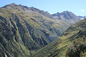
Val Curnera with dam and Piz Máler (left) |
||
| height | 2790 m above sea level M. | |
| location | Surselva , Canton of Graubünden , Switzerland | |
| Mountains | Gotthard massif | |
| Dominance | 1.7 km → Tours Paradis | |
| Notch height | 210 m ↓ Fuorcla da Tuma | |
| Coordinates | 699 050 / 165529 | |
|
|
||
The Piz Máler ( 2790 m above sea level ) is a mountain in the eastern Gotthard massif and is located in the canton of Graubünden in Switzerland .
location
Together with Badus ( 2928 m above sea level ), a little over five kilometers to the west, and Piz Giuv on the opposite side of the valley, the Piz Máler forms the frame of the uppermost Vorderrhein Valley (Surselva) just below the Oberalp Pass . The Piz Máler forms the northern end of a side chain that branches off at Piz Blas ( 3,019 m above sea level ) north of the ridge that forms the canton's border with Ticino . This ridge is framed on both sides by deeply cut valleys, in the west by the Val Curnera with the Lai da Curnera , in the east by the Val Nalps with the Lai da Nalps .
The southern neighbors of Piz Máler in this ridge are Piz Ner ( 2762 m above sea level ) and Piz Paradis ( 2884 m above sea level ), of which the Piz Máler passes through the Fuorcla da Tuma ( 2580 m above sea level ). is separated.
Routes
The Piz Máler is best known as a ski touring destination . The ascent is usually over the not too steep northeast ridge. The starting point is usually the hamlet of Surrein ( 1380 m above sea level ), a little south of Sedrun . If necessary, the ascent can be shortened by using the cable car to Lai da Nalps, east of the mountain. The descent can also be made through the steep north side of the mountain, depending on the conditions.
literature
- Michael Pröttel: Surselva: Laax - Flims - Disentis - Vals - San Bernardino - Juf. 50 selected ski tours in the Bündner Oberland and on the Hinterrhein. 2nd updated edition. Bergverlag Rother, Munich 2008, ISBN 978-3-7633-5921-9 .
Web links
- Piz Máler at hikr.org
Individual evidence
- ^ Charles Knapp, Maurice Borel, Victor Attinger, Heinrich Brunner, Société neuchâteloise de geographie (editor): Geographical Lexicon of Switzerland . Volume 3: Krailigen - Plentsch . Verlag Gebrüder Attinger, Neuenburg 1905, p. 278 f., Keyword Malèr (Piz del) ( scan of the lexicon page ).
- ↑ Piz Máler in the Swisstopo geodata viewer. In: swisstopo.ch. Federal Office for Topography . Status: December 2019.
- ↑ Michael Pröttel: Surselva: Laax - Flims - Disentis - Vals - San Bernardino - Juf. 50 selected ski tours in the Bündner Oberland and on the Hinterrhein. 1st edition. Bergverlag Rother, Munich [ie] Ottobrunn 2008, ISBN 978-3-7633-5921-9 , pp. 132-135.

