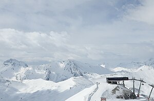
Piz Rots
| Piz Rots | ||
|---|---|---|
|
Piz Rots from the Greitspitz , on the left Stammerspitze |
||
| height | 3097 m above sea level M. | |
| location | Graubünden / Tyrol border | |
| Mountains | Samnaun group | |
| Dominance | 3 km → Stammerspitze | |
| Notch height | 280 m ↓ Fuorcla Chamins | |
| Coordinates , ( CH ) | 46 ° 55 '31 " N , 10 ° 18' 58" O ( 819 101 / 201142 ) | |
|
|
||
| First ascent | 1849 | |
The Piz Rots ( ), also called Piz Roz or Vesilspitze , is 3097 m above sea level. M. high mountain in the Samnaun group , a mountain range in the central Alps , on the Austrian-Swiss border .
Location and surroundings
At the western end of the Samnaun valley , the Piz Rots lies on the municipality border between Samnaun in the east, the Val Sinestra in the Lower Engadine municipality of Valsot in the south and the Tyrolean municipality of Ischgl in the northwest. To the north of the summit lies the Zeblasjoch ( 2539 m above sea level , Fuorcla Zeblas, Samnaunerjoch ), in the west the ridge continues to Piz Val Gronda and the Fimbatal , the southeast ridge connects it via Sulnerspitz ( 3034 m ) and Piz Chamins ( 2928 m ) with the stem tip .
The mountain is mainly made up of shale rock. The small Sulner glacier is located below the northeast face . Large parts of the glacier are buried under schist rubble, so the actual size is difficult to see.
Climbs
The Vesilspitze is considered to be relatively easy to climb. A pathless ascent leads over the west ridge either from Ischgl through the Fimba and Vesil valleys or from the Heidelberger Hut to the summit. The Vesilspitze can be reached from the Zeblasjoch via the north ridge, access to the yoke is possible from Samnaun or the Fimbatal. The straight north ridge is more difficult ( difficulty level II according to UIAA ). Other routes lead over the Sulnerferner, through the Schrofen- pierced southern flank and over the southeast ridge from the Sulnerspitze (II).
The Piz Rots in 1849 by J. topographic Coaz during work first climbed .
literature
- Paul Werner, Ludwig Thoma: Alpine Club Leader Samnaun Group . Ed .: German Alpine Association , Austrian Alpine Association , Alpine Association South Tyrol . 2nd Edition. Rother, Munich 1982, ISBN 3-7633-1241-2 , p. 192-198 .
Web links
- View of the Zeblasjoch and Piz Rots. hikr.org


