Plácky
| Plácky | ||||
|---|---|---|---|---|
|
||||
| Basic data | ||||
| State : |
|
|||
| Region : | Královéhradecký kraj | |||
| District : | Hradec Králové | |||
| Municipality : | Hradec Králové | |||
| Area : | 167.5007 ha | |||
| Geographic location : | 50 ° 14 ' N , 15 ° 49' E | |||
| Height: | 246 m nm | |||
| Residents : | 1,183 (March 26, 2011) | |||
| Postal code : | 500 02, 503 01 | |||
| License plate : | H | |||
| traffic | ||||
| Street: | Hradec Králové - Plotiště nad Labem | |||
| Railway connection: | Pardubice – Liberec | |||
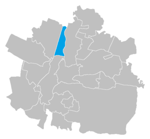
| Location of Plácky in the Hradec Králové district | ||||

|
||||
Plácky (German Platzka , formerly Platzky ) is a district of the city of Hradec Králové in the Czech Republic . It is located two kilometers north of the city center of Hradec Králové and belongs to the Okres Hradec Králové .
geography
Plácky extends on the right side of the Elbe between the river and the Elbgraben ( Labský náhon ) in the Východolabská tabule (table land on the eastern Elbe ). The Pardubice – Liberec railway line forms the western boundary of the district ; the southern, the Chlumec nad Cidlinou – Międzylesie railway line . To the northeast is the Hradec Králové airfield, to the southwest the main train station .
Neighboring towns are Předměřice nad Labem , Kydlinov and Správčice in the north, Rusek in the northeast, Věkoše in the east, Slezské Předměstí in the southeast, Pražské Předměstí in the south, Svobodné Dvory in the southwest and Plotiště nad Labem in the west.
history
The meadows between the Elbarmen north of Königgrätz remained uninhabited for a long time and were used by the residents of Plotiště as communal pastureland. In 1538 the Kydlinov water mill was built in the Elbe meadows near Plotiště; the miller Mikuláš Kydlín approved the municipality of Königgrätz to conduct water from his ditch created near Předměřice to the Březhrad pond. The contractually imposed delivery of a sufficient amount of water to the Březhrad mill on his successors led to protracted disputes between the owner of the Kydlinov mill, Jan Střemcha, and the millers in Valša, Temešvár and Březhrad, who did not consider this obligation to have been fulfilled .
The first chalets were built on the moat around 1750, the small settlement belonging to Plotiště was initially called Plotiště u Náhona . The first evidence of the place name derived from Platzky is found in 1799 in the parish chronicle of Plotiště.
In 1836 the village of Platzky , also called Platzka , Placky or Placka , consisted of 27 houses with 181 inhabitants. 16 of them belonged to the imperial and royal rule Königgrätz, 11 houses with 73 inhabitants belonged to the city of Königgrätz. The mill with a leather mill belonged to the urban part. The parish was a plot table . Until the middle of the 19th century, the village remained partly subject to the imperial and royal rule of Königgrätz and the city of Königgrätz.
After the abolition of patrimonial Placky formed from 1849 a district of the community Plotiště in the judicial district of Königgrätz . From 1868 the village belonged to the Königgrätz district . In 1890 Plácky or Plácka, including the Kydlinov mill, consisted of 33 houses and had 391 inhabitants. In 1910, work began on regulating the Elbe by the company Kress & Bernard, Prague. In the years 1911–1912 the new road to Věkoše including the Kameňák bridge was built . In the course of the territorial expansion of the city of Königgrätz, the incorporation of Plotiště nad Labem and Plácky was planned for 1918; however, it did not materialize because of the political events. During the German occupation , Plotiště nad Labem / Zaunfeld and the district of Plácky / Platzka were incorporated into Königgrätz on April 1, 1942. The Kydlinov mill was nationalized in 1948 and assigned to the Hradec Králové State Estate as the Kydlinov farm. On May 17, 1954, Plácky became an independent municipality in Okres Hradec Králové-okolí, and in August of the same year the volunteer fire brigade was founded. Since the territorial reform of 1960, the municipality belonged to the Okres Hradec Králové. On November 26, 1971, Plácky was again incorporated into the city of Hradec Králové. On March 3, 1991 the place had 1123 inhabitants; in the 2001 census, 1072 people lived in the 307 houses in Plácky.
Local division
The district of Plácky consists of the basic settlement units Plácky and Zaertrí. The one-shift Kydlinov also belongs to Plácky.
The district forms a cadastral district.
Attractions
- Kameňák road bridge over the Elbe between Plácky and Věkoše, it was built in the years 1911–1912 according to plans by the hydraulic engineer František Sander by the construction company František Jirásek from Hradec Králové for 57,000 crowns. The Art Nouveau building is protected as a technical monument and was completely renovated between 1998 and 1999 for 7 million crowns.
- Mühlengut Kydlinov, it was built in 1538 and has been privately owned again since 1992
- Statue of St. John of Nepomuk in Kydlinov
- Stone cross in Plácky
Web links
- The history of Plácky on the website of the Plácky Volunteer Fire Brigade
- Website of the local self-government commission Plácky (Komise místní samosprávy)
- Plácky on the website of the District Archives Hradec Králové
Individual evidence
- ↑ http://www.uir.cz/katastralni-uzemi/721204/Placky
- ^ Johann Gottfried Sommer , Franz Xaver Maximilian Zippe: The Kingdom of Böhmen. Statistically and topographically presented, Vol. 4 Königgrätzer Kreis , Prague 1836, pp. 29–30
- ↑ Ottův slovník naučný . Devatenáctý díl. Praha: J. Otto, 1902. P. 827. Online version
- ↑ https://www.czso.cz/documents/10180/20565661/13810901.pdf/3fde2441-c81b-4a1e-9b94-551e65007f70?version=1.0
- ↑ http://www.uir.cz/zsj-casti-obce/121207/Cast-obce-Placky
- ↑ http://www.hkregion.cz/dr-cs/100166-silnicni-most-placky-hradec-kralove.html


