
Drought wall
| Drought wall | ||
|---|---|---|
 Öhler ( 1183 m above sea level ) |
||
| height | 1222 m above sea level A. | |
| location | Lower Austria , Austria | |
| Mountains | Mountain range 1862 to Trimmel , Gutenstein Alps | |
| Dominance | 8.4 km → Schneeberg | |
| Notch height | 261 m ↓ Schoberkapelle | |
| Coordinates | 47 ° 49 '59 " N , 15 ° 55' 17" E | |
|
||


The Dürre Wand is a mountain range in Lower Austria and, topographically, belongs to the Gutenstein Alps . It extends from Miesenbach in the direction of the WSW, up to the Schneeberg . The Dürre Wand is a mountain ridge, partly interspersed with rocks, which is bordered by alpine pastures, forests and waterfalls. In contrast to the neighboring high plateau of the Hohe Wand to the east , it forms a partially narrow ridge. The Austrian long-distance hiking trail 01 runs over the ridge and has several sections with great views.
Elevations, shelters and hiking trails
The mountain range of the Dürren Wand is described in detail below from ONO to WSW.
- Martersberg ( 918 m above sea level ). Inconspicuous wooded elevation at the beginning of the ridge. No marked path to the highest point; the long-distance hiking trail crosses its southern flank.
- Plattenstein ( 1154 m above sea level ). Thanks to its rocky north flank, one of the most striking points on the entire ridge, with a clear view of the Piesting valley and the Schneeberg . A few meters below its highest point is the Gauermannhütte of the ÖTK , built by the Viennese Alpine Society Waldegger and opened on October 25, 1908 . Shortest access from the Tiefenbach homestead : via the Ochsenweg about 1½ hours, via the Schwaighofer homestead and the Ostkamm 1½ to 2 hours walk.
- Katharinenschlag ( 1222 m above sea level ). The highest point on the ridge, which is flatter especially on the south side, is a little noticeable elevation. Is usually only visited when crossing the ridge, with the marked path leading past just south of the summit.
- Öhlerschutzhaus der Naturfreunde . ( 1027 m above sea level ). Opened in 1928. Access: from the north from Brandstätterhof about 1½ hours, from the south from Puchberg am Schneeberg via Haltberg about 2 hours.
- Öhler ( 1183 m above sea level ). Good vantage point, reachable from the Öhlerschutzhaus over its gentle eastern flank in ½ hour. To the south too pronounced rock walls; The further ridge path to the Schober in the west also has short sections of rock. The long-distance hiking trail 01 follows the Imitzerweg from the Öhlerschutzhaus , which leads south of the rocky ridge directly to the Schoberwiese .
- Schober ( 1213 m above sea level ). Most western peak in the ridge with pronounced steep slopes. Wooded peak with a cross, but no view; unobstructed view of the Schneeberg from the western flank. Accessible from the Mamauwiese via the Schoberkapelle , then in steep turns to the summit; Walking time about 1 hour.
caves
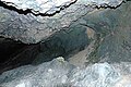
The "Tablerhöhle 1862/10" east of the slab stone and the "Erzloch 1862/4", a shaft cave east of the Öhlerschutzhaus, are two caves directly on the crest of the Dürren Wand. Other important caves are the "Malepartuskluft 1862/19", "Bergmilchkammer 1862/20", "Marechlehöhle 1862/21", "schichtkammer 1862/23 "and the" Vierpfeilerhöhle 1862/24 "(all in the Marecherkogel south of the Öhler near Puchberg am Schneeberg), the "Zinsensteinhöhle 1862/11" and the "Waldbodenloch 1862/61" (all in the north of the Dürren Wand near Gutenstein). A total of 104 caves are recorded in the cave cadastre for the area 1862 - Dürre Wand.
photos

Schober ( 1213 m above sea level )
View from Katharinenschlag ( 1222 m above sea level )
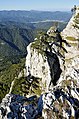
Plattenstein ( 1154 m above sea level )

View from the Plattenstein

Gauermannhütte (west side)

Gauermannhütte (east side)

Emergency camp next to the Gauermannhütte

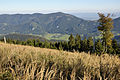
Looking west to the foothills of the Hohe Wand

Öhlerschutzhaus
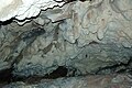
Mountain milk chamber 1862/20

Malepartuskluft 1862/19
Marechle Cave 1862/21

Schoberbachklammhöhle 1862/55
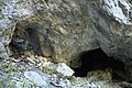
Lower Öhler Cave 1862/39


.jpg)
.jpg)


literature
- Speleological communications . Regional association for caving in Vienna and Lower Austria, Vienna 1.1945 - 48.1992, ZDB -ID 952453-8 .
- Max H. Fink (Red.): The caves of Lower Austria. South-eastern Lower Austria and peripheral areas . Volume 1. Scientific supplements to the journal “Die Höhle”, Volume 28, ZDB -ID 505211-7 . Regional Association for Speleology in Vienna and Lower Austria, Vienna 1979.
- Helga and Wilhelm Hartmann (Red.): The caves of Lower Austria . Volume 4. Scientific supplements to the journal “Die Höhle”, Volume 37, ZDB-ID 505211-7. Regional association for caving in Vienna and Lower Austria, Vienna 1990.
- Kurt Kettner (among others): Eastern Alps. Refuge huts in Germany, Austria and South Tyrol. 1074 shelters and bivouac boxes of the DAV, OeAV, AVS and CAI as well as numerous other alpine associations and private managers . 9th edition. The Alpine Club huts. Volume 1. Bergverlag Rother , Munich 2005, ISBN 3-7633-8073-6 .
- Adi Mokrejs: Mountain Hiking Atlas Lower Austria. Over 200 of the most beautiful mountain hikes as well as variants and mountain tours . Second, expanded and updated edition. Schall-Verlag, Alland 2012, ISBN 978-3-900533-66-3 .
Web links
- Gauermannhütte.
- Öhlerschutzhaus.
- Association of Austrian Speleologists (VÖH).
- Magnificent instead of arid : hiking tip from the daily Der Standard , April 29, 2011, accessed on July 16, 2013.
- On Sunday we go ... From Miesenbach to the Dürre Wand. In: Wiener Zeitung , No. 210/1935 (CCXXXII. Volume), August 1, 1935, p. 8, top left. (Online at ANNO ). .
Individual evidence
- ↑ Small messages. Protective houses. In: Der Naturfreund , year 1908, No. 11, November 15, 1908 (XII. Year), p. 251, center left. (Online at ANNO ). .
- ↑ Kettner: Schutzhütten , p. 231, online , accessed on October 4, 2010.
- ↑ Kettner: Schutzhütten , p. 232, online , accessed on October 4, 2010.
- ^ Association news. (...) The Friends of Nature House on the Öhler. In: Der Naturfreund , born 1928, XXXII. Volume, p. 93 f. (Online at ANNO ). .
-
↑ Numerical additions to a cave name refer to the Austrian Cave Directory (ÖHV) , which, for the area of Lower Austria based on the cadastral associations:
Regional Association for Speleology in Vienna and Lower Austria ,
Neunkirchen Research Group of the Regional Association for Speleology in Vienna and Lower Austria ,
diving and Driving club Hannibal
as well as the
“Speleological Group” of the Austrian Tourist Club (ÖTK) , run
by the Karst and Speleological Department of the Association of Austrian Speleologists . - ^ Fink: Höhlen Niederösterreichs , passim and Hartmann: Höhlen Niederösterreichs , passim.
- ^ Speleological communications , passim.