Pliva (Vrbas)
|
Pliva Плива |
||
|
Waterfall with which the Pliva (left) flows into the Vrbas (right) |
||
| Data | ||
| location | Bosnia and Herzegovina | |
| River system | Danube | |
| Drain over | Vrbas → Save → Danube → Black Sea | |
| source | Smiljevac-Jastrebnjak 44 ° 20 '16 " N , 17 ° 16' 14" O |
|
| Source height | 485 m | |
| muzzle | in the Vrbas (river) coordinates: 44 ° 20 ′ 15 ″ N , 17 ° 16 ′ 14 ″ E 44 ° 20 ′ 15 ″ N , 17 ° 16 ′ 14 ″ E |
|
| Mouth height | 350 m | |
| Height difference | 135 m | |
| Bottom slope | 4.1 ‰ | |
| length | 33 km | |
| Catchment area | 768 km² | |
| Right tributaries | Janj | |
| Medium-sized cities | Jajce | |
| Navigable | not navigable | |
|
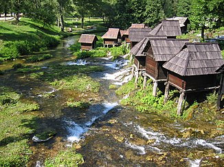
Watermills on the Pliva |
||
The Pliva ( Serbian - Cyrillic Плива ) is a 33 km long river in central Bosnia . It rises above Šipovo at the foot of a karst plateau, flows through the town of Šipovo, where the Janj flows in from the right , and on through Jezero to Jajce , where it flows into the Vrbas below the old town as a 20-meter high waterfall . A few kilometers upstream before Jajce, the Pliva widens to the Great Pliva Lake (Veliko Plivsko jezero) and then to the Small Pliva Lake (Malo Plivsko jezero) . There are around 20 water mills between the two lakes, the origins of which can be traced back to the time of the Ottoman occupation. Today the main importance of the river and the lakes is in tourism.

