Polleskogel
| Polleskogel | ||
|---|---|---|
|
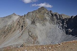
Polleskogel from the southwest, from the path to the Braunschweiger Hütte |
||
| height | 3035 m above sea level A. | |
| location | Tyrol , Austria | |
| Mountains | Ötztal Alps | |
| Dominance | 0.5 km → Karleskogel | |
| Notch height | 74 m ↓ South Pollesjoch | |
| Coordinates | 46 ° 56 '40 " N , 10 ° 55' 11" E | |
|
|
||
| Normal way | Via Mainzer Höhenweg and northwest ridge ( I ) | |
The Polleskogel , actually Northern Polleskogel , is 3035 m above sea level. A. high peak in the Geigenkamm in the Ötztal Alps in Tyrol . The Mainzer Höhenweg , a high alpine path from the Rüsselsheimer Hütte to the Braunschweiger Hütte , leads in the variant to the Rettenbachferner a few meters past the summit.
Routes
The shortest ascent is from the parking lot on the Rettenbachferner at the end of the Ötztaler Gletscherstrasse . From there over rubble up to the rock and steep, partly with chain guards, through a channel into a gap (approx. 3000 m) between the northern and the insignificant southern Polleskogel ( 3005 m above sea level ). Shortly down and up again into a gap in the northwest ridge (approx. 3010 m). Here on the right a few more meters through block and rock terrain (I) to the highest point.
Back from the gap in the north-west ridge , going further north you reach the confluence of the Franz-Auer-Steig , which offers a connection to the Braunschweiger Hütte.
Demarcation
In some tour descriptions, the climb is led from the Rettenbachferner over the southern Pollesjoch (2961 m), the deepest saddle in the ridge heading south to the Karleskogel . The southern Pollesjoch is not touched during the ascent. In the picture with the view from the southeast, the southern Pollesjoch is the notch on the left edge of the picture. However, the path runs over the notch in the center of the picture (signpost recognizable), between the southern (left of the notch) and the northern Polleskogel (right of the notch).
Literature and map
- Walter Klier: Alpine Club Guide Ötztal Alps. Bergverlag Rudolf Rother, Munich 2006, ISBN 3-7633-1123-8
- Alpine Club Card, sheet 30/5, 1: 25,000, Ötztal Alps, Geigenkamm. ISBN 3-928777-44-0


