
Karleskogel
| Karleskogel | ||
|---|---|---|
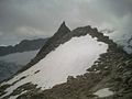
 Karleskogel from the Braunschweiger Hütte |
||
| height | 3107 m above sea level A. | |
| location | Tyrol , Austria | |
| Mountains | Ötztal Alps | |
| Dominance | 1 km → Innere Schwarze Schneid | |
| Notch height | 117 m ↓ Rettenbachjoch | |
| Coordinates | 46 ° 56 '14 " N , 10 ° 55' 20" E | |
|
||
| First ascent | August 23, 1890 by Ludwig Purtscheller | |
| Normal way | North ridge ( II ) | |

The Karleskogel ( 3107 m above sea level ) is a summit of the Weißkamm , a mountain range of the Ötztal Alps . Seen from the north, it is one of the “foremost” mountains of this ridge and is located near the junction of the violin ridge . Its north ridge runs directly down to the Pitztaler Jöchl , an important transition from the Ötztal to the Pitztal . It is considered by mountaineers to be the 'hut mountain' of the Braunschweiger hut (hence the nickname Hüttenwandl ) and is often climbed from this hut, especially during climbing courses. Its extremely rugged ridge is provided with numerous towers and continues south to the Rettenbachjoch.
In ancient times the mountain was also called the Rettenbachfernerkogel .
Ascent history
On August 23, 1890, Ludwig Purtscheller set out from Sölden in the Ötztal at around 4:30 am local time . He climbed up the path through the Rettenbach valley, which was steep at first, then gently climbed. At the end of the valley, Purtscheller turned northwest, then west towards the northern arm of the Rettenbachferner , below the Pitztaler Jöchl. There he turned to the SW and climbed the very steep firn slopes there, where the Linke Fernerkogel was also visible. He reached the summit after a short but difficult climb at around 9:15 am He descended on the same path.
Routes
- Normal route (from the north): From the Braunschweiger Hütte on the marked trail to the Pitztaler Jöchl. From the Ötztal through the Rettenbachtal over the Rettenbachferner also to the Pitztaler Jöchl. Now head south over the rapidly dividing ridge next to a firn field. Either you cross over to the east and climb the edge of the firn plateau over the steep firn field further to the left (be careful of the slope crevice) or you climb slightly to the left of the ridge over extremely steep blocky rocks and gain the plateau there (II). Across the wide, east sloping firn field in the direction of the steeply rising summit structure. Completely free of snow, you cross the field directly to the left of the blocky ridge. At the southern end of the plateau on narrow ledges and ledges diagonally down to directly below the summit structure formed by large blocks. You change to a rubble channel that goes up in the direction of the ridge and climb up a little until steep, blocky rocks on the left allow you to climb higher. Steep up in the rock in the direction of the ridge, up to the sharp ridge tower (II). Right on a narrow ledge past the tower to next to the summit block. In a narrow niche the last few meters up to the summit with a pole (II).
- (From the Rettenbachjoch): From the Rettenbachjoch difficult (III) over the ridge with numerous towers to the north. You bypass or climb over the towers and reach the summit in a difficult climb.
Impressions

Karleskogel from the north
On the plateau

The summit structure of the Karleskogel

At the summit


Literature and map
- Walter Klier : Alpine Club Guide Ötztaler Alpen , Bergverlag Rudolf Rother , Munich 2006, ISBN 3-7633-1123-8 .
- Ludwig Obersteiner: Guide through the Ötztal Alps, Reichenstein Verlag, 1937 (2nd edition).
- Alpine club map sheet 30/5, 1: 25,000, Ötztal Alps, Geigenkamm , ISBN 3-928777-44-0 .
Individual evidence
- ↑ H. Heß / L. Purtscheller : The high tourist in the Eastern Alps , 1903, vol. I, p. 228 (98)
- ↑ Prof. E. Richter: The development of the Eastern Alps , Vol. II, p. 297/98.