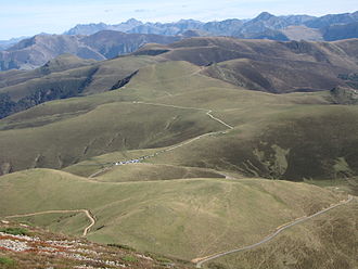
Port de Balès
| Port de Balès | |||
|---|---|---|---|
|
|
|||
| Compass direction | North | south | |
| Pass height | 1755 m | ||
| Department | Hautes-Pyrénées | Haute-Garonne | |
| Valley locations | Mauléon-Barousse | Bagneres-de-Luchon | |
| expansion | D 925 | D 51 | |
| Built | 2006 | ||
| Mountains | French Pyrenees | ||
| profile | |||
| Mountain scoring | HC | ||
| Ø pitch | 6.3% (1185 m / 18.87 km) | 5.7% (1125 m / 19.66 km) | |
| Max. Incline | 11.1% | 11.2% | |
| map | |||
|
|
|||
| Coordinates | 42 ° 52 '25 " N , 0 ° 29' 59" E | ||
The Port de Balès is a 1,755 meter high mountain pass in the French Pyrenees . A 19.2-kilometer climb on a small road with an average gradient of 6.2% leads to the pass. In the Tour de France he is therefore classified in the highest category ( Hors Catégorie ). The continuous asphalt expansion of the Port de Balès was not completed until the summer of 2006, before the southern ramp was only gravel. From the top of the pass, the D 925 leads a further 3.5 kilometers to the west to the 1,855 meter high Port de Pierrefite .
Tour de France
On July 23, 2007 on the 15th stage , the Port de Balès was used for the first time in the Tour de France. The first rider to climb the summit was Kim Kirchen from Luxembourg . In the following years the pass was a regular part of the tour route.
Mountain classification winner
| year | stage | category | winner |
|---|---|---|---|
| 2014 | 16 | HC | José Serpa |
| 2012 | 17th | HC | Alejandro Valverde |
| 2010 | 15th | HC | Thomas Voeckler |
| 2007 | 15th | HC | Kim churches |

