Post intervals
| Post intervals | ||
|---|---|---|
| Basic data | ||
| Residents (state) | 1259 pop. (2012 census) | |
| height | 1843 m | |
| Post Code | 07-0804-0100-1004 | |
| Telephone code | (+591) | |
| Coordinates | 18 ° 29 ′ S , 63 ° 50 ′ W | |
|
|
||
| politics | ||
| Department | Santa Cruz | |
| province | Vallegrande Province | |
| climate | ||
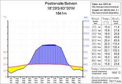
 Climate diagram post intervals |
||
Postrervalle is a town in the Santa Cruz Department in the South American Andean state of Bolivia .
Location in the vicinity
Postrervalle is the central place of the district ( Bolivian : Municipio ) Postrer Valle in the province of Vallegrande . The village is located at an altitude of 1841 m on the upper reaches of the Río Vilcas , a left tributary of the Río Masicurí , which flows into the Río Grande . Postrervalle is located on a plain surrounded by mountain ridges up to 2 km wide and almost 5 km long, which is used intensively for agriculture, the ridges around the valley of Postrervalle rise to almost 2,500 m height.
geography
Postrervalle lies in the transition area between the Andes mountain range of the Cordillera Oriental in the north, the Cordillera Central in the southwest and the Bolivian lowlands in the east. The climate in the protected valley location is mild and balanced all year round, but less warm than in the neighboring municipality of Vallegrande.
The mean average temperature of the region is just under 19 ° C (see climate diagram Postrervalle) and fluctuates only insignificantly between just under 16 ° C in June / July and just under 21 ° C from November to January. The annual precipitation is about 750 mm, with a dry season from May to September with monthly precipitation below 30 mm, and a wet season from December to February with 115 to 135 mm monthly precipitation.
Transport network
Postrervalle is located at a distance of 179 kilometers by road southwest of Santa Cruz , the capital of the department.
Santa Cruz of the 488 km long leads highway Ruta 7 about La Guardia and La Angostura to Samaipata and then continue on Mairana and Comarapa to Cochabamba , the capital of neighboring departments. From the southern edge of the city of Samaipata, an unpaved road leads south and reaches San Juan del Rosario after 22 kilometers , the road then continues for 37 kilometers to Postrervalle .
population
The town's population has more than doubled over the past two decades:
| year | Residents | source |
|---|---|---|
| 1992 | 535 | census |
| 2001 | 1 101 | census |
| 2012 | 1 259 | census |
Individual evidence
- ^ Instituto Nacional de Estadística Bolivia (INE) 1992
- ^ INE - Instituto Nacional de Estadística Bolivia 2001
- ↑ INE - Instituto Nacional de Estadística Bolivia 2012 ( Memento of the original from July 22, 2011 in the Internet Archive ) Info: The archive link has been inserted automatically and has not yet been checked. Please check the original and archive link according to the instructions and then remove this notice.
Web links
- Relief map of the Vallegrande region 1: 250,000 (PDF; 8.75 MB)
- Municipio Postrer Valle - General Maps No. 70804
- Municipio Postrer Valle - detailed map and population data (PDF; 862 kB) ( Spanish )
- Department Santa Cruz - Social data of the municipalities (PDF; 4.99 MB) ( Spanish )
