Puerto Ocopa
| Puerto Ocopa | ||
|---|---|---|
|
|
||
| Coordinates | 11 ° 9 ′ S , 74 ° 18 ′ W | |
| Basic data | ||
| Country | Peru | |
| Junín | ||
| province | Satipo | |
| ISO 3166-2 | PE-JUN | |
| District | Río Tambo | |
| height | 323 m | |
| Residents | 754 (2017) | |
Puerto Ocopa is a place in the Junín region in eastern Peru .
location
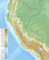
Puerto Ocopa is located in the Peruvian Eastern Cordillera at the confluence of the Río Pangoa into the Río Perené , shortly before it joins the Río Apurímac to the Río Tambo . The place is at an altitude of 323 m .
Puerto Ocop is located 500 kilometers northeast of the Peruvian capital Lima , a three- hour drive from the nearest larger city of Satipo .
population
Puerto Ocopa has a population of 754 (2017 census) with a decreasing trend, of which 50% are children, two thirds of whom are orphans as a result of the fighting of the terrorist organization Shining Path against the Peruvian army .
history
Puerto Ocopa was founded by Franciscans in the Asháninka region in 1922 with the declared aim of giving orphaned children in the Franciscan Mission a new home. Today, several thousand resettled Asháninka live in the region around Puerto Ocopa.
Others
Puerto Ocopa has two airplane runways with a length of 1220 m each.
