Qafa e Malit
| Qafa e Malit | |||
|---|---|---|---|
|
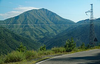
Maja e Roshit from the north with the Qafa e Malit on the far right and the Qafa e Mollës on the far left and the SH5 just above the power cables |
|||
| Compass direction | west | east | |
| Pass height | 955 m above sea level A. | ||
| Qark | Shkodra | ||
| Watershed | Fan i Madh ( Mat ) | Goçka e Madhe ( Drin ) | |
| Valley locations | Fushë-Arrëz | Lajthiza | |
| expansion | Street | ||
| Lock | - | ||
| Mountains | Mountains of Puka / Mirdita | ||
| profile | |||
| Ø pitch | 3.5% (350 m / 10 km) | 4.1% (370 m / 9 km) | |
| map | |||
|
|
|||
| Coordinates | 42 ° 5 '48 " N , 20 ° 7' 7" E | ||
The Qafa e Malit ( German : mountain pass ) is a 955 m above sea level. A. high mountain pass in northern albania . It lies on the watershed between the Fan i Madh and the Drin in the highlands of Puka and the northern Mirdita .
Immediately southeast of the pass, around a kilometer away, is the summit of the Maja e Roshit mountain ( 1397 m above sea level ). A little more than a kilometer to the north rises the mountain peak Maja e Malit ( mountain peak ; 1025 m above sea level ). One of the source streams of the Fan i Madh rises on the west side of the pass. The valley of Goçka e Madhe in the northeast of the pass slopes down to the Fierza reservoir about ten kilometers away .
The region is only very sparsely populated and is known for its extensive black pine forests . There is also an important beech forest not far from the pass .
The national road SH 5 runs over the pass, from Shkodra via Vau-Deja and Puka to Kukës and to the border with Kosovo . In the west, the pass road starts in Fushë-Arrëz at 605 m above sea level. A. and after about two thirds of the ascent passes the place Qafë-Mal . The road climbs steeply, especially in the last part, and winds up the pass in a few curves. On the east side, the road runs almost four kilometers along the northern flank of the Maja e Roshit, without losing much of its height. Only after it has come around a ridge into the valley of the Goçka e Vogël brook does it begin to descend. It circles the village of Lajthiza to the south and descends to the valley floor (below 600 m above sea level ) and then ascends on the other side of the valley (now in Qark Kukës ) to the pass Qafa e Shllakut ( 808 m above sea level ) .
One and a half kilometers east of the Qafa e Malit is the Qafa e Mollës pass ( ⊙ Apple Pass ). This just over 1000 m above sea level. A. high pass is a direct connection between the Qafa e Malit and Lajthiza. There is only one mule track over the Qafa e Mollës. The road runs around 60 meters below the pass and makes a two-kilometer curve to the northeast, around the Kodra e Madhe ridge .
500 meters northwest and around 75 meters below the pass, the SH 22 branches off , which leads high above the Fierza reservoir to Fierza and on to Tropoja .
The Qafa e Malit has been celebrated for a long time. A caravan route connecting Shkodra with Kukës led over the pass. At the beginning of World War II, the Italian occupiers built the road over the pass. For a long time, the pass remained the only direct connection connecting Kukës and the north-east of the country with the capital Tirana and the coastal region. The drive to Tirana took around eight hours, and the pass - often with snow and ice on the road - symbolized a long, arduous journey. Only the opening of the A1 motorway in 2010 brought a convenient connection to the northeast and relieved the SH5 of long-distance and heavy traffic.
In winter it happens again and again that snowfalls block the pass.
Individual evidence
- ^ Trifon Ziu: Fjalor enciklopedik shqiptar . Ed .: Akademia e Shkencave e RPSSH. Tirana 1985, keyword Qafa e Malit , p. 884 .
- ↑ Akademia e Shkencave e RPSSH (ed.): Gjeografia fizike e Shqipërisë . tape 2 . Tirana 1990, p. 155, 158 .
- ↑ a b Official map 1: 50,000 of the military cartographic office of Albania, sheet K-34-65-C Fushë-Arrëzi , 2nd edition 1988.
- ↑ Akademia e Shkencave e RPSSH (ed.): Gjeografia fizike e Shqipërisë . tape 2 . Tirana 1990, p. 152, 162 .
- ↑ a b Herbert Louis: Albania. A study of the country mainly due to my own travels . Published by J. Engelhorn's successors in Stuttgart, Berlin 1927, p. 141 .
- ↑ Map 1: 50,000 of the Military Cartographic Office of Albania and the National Imagery and Mapping Agency , sheet 3079 II Shënmëri , edition 3-NIMA, Tirana 1998.
- ^ Giuseppe Pini: Strade di ieri e strade di oggi in Albania . In: Albania - Shqipni. Rivista Mensile di politica, economia, scienze e lettere . Anno II, No. 1 . Rome January 1941, p. 28-39 .
- ↑ Kukës-Pukë, shtegu i pajetë që prej "Rrugës së Kombit". In: panorama.com.al. May 14, 2012, accessed May 13, 2020 .
- ↑ Ralph-Raymond Braun: Albania . 1st edition. Michael Müller, Erlangen 2019, ISBN 978-3-95654-473-6 , pp. 128 .
- ↑ Akademia e Shkencave e RPSSH (ed.): Gjeografia fizike e Shqipërisë . tape 2 . Tirana 1990, p. 101 .

