
Qinghai Lake
|
Qinghai Lake 青海 湖 |
||
|---|---|---|

|
||
| Satellite image of Lake Qinghai, 1994 | ||
| Geographical location |
Qinghai PR China |
|
| Tributaries | Buha He , Shaliu, Daotang He | |
| Drain | (no) | |
| Data | ||
| Coordinates | 36 ° 54 ' N , 100 ° 11' E | |
|
||
| Altitude above sea level | 3194 m | |
| surface | 4th 696.77 km² (2004) | |
| length | 108.1 km | |
| width | 67.3 km | |
| volume | 71.6 km³ (2009) | |
| Maximum depth | 27 m (1988) | |
| Middle deep | 14.8 m (1988) | |
| PH value | 9.3 | |
| Catchment area | 29,661 km² | |
|
particularities |
Largest salt lake in China Salt |
|

| Tibetan name |
|---|
|
Tibetan script :
མཚོ་ སྔོན་ པོ །
|
|
Wylie transliteration : mtsho sngon po
|
|
Pronunciation in IPA : [
tsʰo ŋø̃po ]
|
|
Official transcription of the PRCh : Co Ngoinbo
|
|
THDL transcription : Tso Ngönpo
|
| Chinese name |
|
Traditional :
青海 湖
|
|
Simplified :
青海 湖
|
|
Pinyin : Qīnghǎi Hú
|
The Qinghai Lake ( Chinese 青海湖 , Pinyin Qīnghǎi Hú , Tib. མཚོ་ སྔོན་ པོ ་. Wylie mtsho sngon po ) in Mongolian as Koko-nor known, is one of the largest salt lakes of the earth. The Chinese name of the lake Qīnghǎi Hú means "lake of the turquoise sea", whereby the character qīng - 青 in Chinese can mean both the colors "blue-green", "green-blue", "turquoise" and "black" without context . (see green and blue in different languages ) The sign hǎi - 海 means "sea" and hú - 湖 means "lake - inland lake".
location
The lake is located in the Chinese province of Qinghai , the name of which is derived from this lake. It extends to an altitude of 3,195 meters above sea level and, according to official information, has an area of 4,583 km². This probably includes the former bays, some of which are already independent ( Gǎhǎi - 尕 海 with 48.9 km², Shādǎo Hú - 沙岛 湖 19.6 km², Hǎiyàn Hú - 海晏 湖 112.5 km² and others).
In the 1960s, 108 rivers flowing into the lake are said to have been counted, although this number may have a spiritual meaning: The lake is a sacred lake for the Tibetans in Amdo and has thus acquired importance for Tibetan Buddhism in the course of history, in which again 108 represents a sacred number. According to popular belief, the lake was created by the carelessness of a woman who forgot to close the lid after fetching water from the well. Only the Buddha put a stopper in the form of an island in the middle of the lake, thus preventing further overflow. Today there is a Buddhist nunnery on the islet.
Nevertheless, 85 percent of the estuaries are said to have dried up in 2004, including the largest tributary, the 179 km long Buhahe (from Mongolian. Buhain Gol ; Chinese: 布哈 河Bùhā Hé ). However, many small rivers dry up in the extremely low-rainfall winter months of the Tibetan highlands. The Buh He has been on the west side of the Qinghai Hu near the famous bird island ( Niǎo dǎo - 鳥島 / 鸟岛 forming a delta, which together with the) Niao Dao furnished to the 1997 reserve Qinghai Lake Natural Protection Zone belongs.
Farmland developments and climatic variability have caused the lake's water level to drop continuously since 1959, so that the area of the lake has shrunk to 4186 km². As a result of this process, bodies of water that previously belonged to the lake have split off as independent lakes. The connections to Lake Qinghai have dried up. With the abandonment of former arable land and the renaturation of grassland, attempts are being made to stabilize the water balance. The lake area is said to have been 4489 km² in 2007. More than 85,600 people (as of 2004) , mostly shepherds, live in the catchment area of Lake Qinghai.
photos
- Qinghai Lake

View over the south shore of Qinghai Lake, 2006
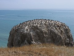
Bird Island ( Niǎo Dǎo ) on the west bank, 2006
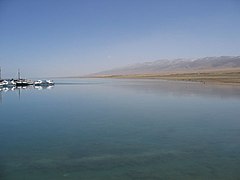
Qinghai Lake ( Qīnghǎi Hú ), May 2006


literature
- Buffetrille, Katia. "The Blue Lake of Amdo and Its Island: Legends and Pilgrimage Guide." In: The Tibet Journal Vol. XIX, No. 4, winter, 1994.
- Gruschke, Andreas: “The realm of sacred lake Kokonor”, in: The Cultural Monuments of Tibet's Outer Provinces: Amdo vol. 1. The Qinghai Part of Amdo , White Lotus Press, Bangkok 2001; pp. 93ff. ISBN 974-7534-59-2
See also
- Tour of Qinghai Lake (cycling race)
- Stephan Kühnrich: Lakes on the Roof of the World, Part 4 (2012), broadcast on 3sat on January 3, 2019, 3: 26–4: 10 p.m.
Web links
Individual evidence
- ↑ a b c d e f Wang, Jianhua, et al. "Evaluation of concordance between environment and economy in Qinghai Lake Watershed, Qinghai-Tibet Plateau." Journal of Geographical Sciences 21.5 (2011): 949-960, doi : 10.1007 / s11442-011-0892-z . ( PDF; 524 kB )
- ↑ a b c NAKAO, Kinshiro, Ryuichi TANOUE, and Muneo OKAYAMA. "Geomorphological history of the basin and the origin of Qinghai Lake, Qinghai Plateau, China." Journal of the Faculty of Science, Hokkaido University. Series 7, Geophysics 9.5 (1995): 509-523. ( PDF; 844 kB )
- ↑ Jull, AJ Timothy, et al. "14 C measurements of dissolved inorganic and organic carbon in Qinghai Lake and inflowing rivers (Ne Tibet, Qinghai Plateau), China." Radiocarbon 56.3 (2014): 1115-1127, doi : 10.2458 / 56.17776 . ( PDF; 0.99 MB )
- ↑ a b Jiang, Hongchen, et al. "Planktonic actinobacterial diversity along a salinity gradient of a river and five lakes on the Tibetan Plateau." Extremophiles 14.4 (2010): 367–376, doi : 10.1007 / s00792-010-0316-5 ( PDF; 560 kB )
- ^ Term Qing - 青 : (Chinese) [1] , In: dict.revised.moe.edu.tw, accessed on February 3, 2019 - Online
- ^ Term Qing - 青 : (Chinese) [2] , In: www.ciyang.com, accessed on February 3, 2019 - Online
- ↑ Term Qing - 青 : (Chinese, German) [3] , In: dict.leo.org, accessed on February 3, 2019 - Online
- ^ Term Hai - 海 : (Chinese) [4] , In: www.ciyang.com, accessed on February 3, 2019 - Online
- ↑ Term Hai - 海 : (Chinese, German) [5] , In: dict.leo.org, accessed on February 3, 2019 - Online
- ^ Term Hu - 湖 : (Chinese) [6] , In: www.ciyang.com, accessed on February 3, 2019 - Online
- ^ Term Hu - 湖 : (Chinese, German) [7] , In: dict.leo.org, accessed on February 3, 2019 - Online
- ↑ Qinghai Sheng Dituce [Atlas of Qinghai Province], Xi'an 2003, p. 14
- ↑ Stephan Kühnrich, Lakes on the Roof of the World (3sat, broadcast on January 5, 2019)
- ↑ More Birds in Qinghai Lake
- ↑ Qinghai Province Weather Bureau ( Memento of August 28, 2008 in the Internet Archive ), accessed June 7, 2019 (English)