Qualla Boundary
The Qualla Boundary or The Qualla is an area held in trust for the nationally recognized tribe of the Eastern Band of Cherokee Indians . The area is located in western North Carolina and is part of the Cherokee Historic Tribal Areas . The area is not an Indian reservation , but the land was bought by the tribe in the 1870s and later state protection was given. Land can be bought and sold as long as the owner and purchaser are registered members of the Eastern Band of Cherokee Indians (EBCI).
location
The Qualla Boundary covers approximately 230 square kilometers in western North Carolina . Most of the land is in eastern Swain and northern Jackson Counties. A smaller portion of the area extends east into Haywood County , just south of the Great Smoky Mountains National Park . The boundary includes many smaller, non-contiguous areas in the southwest in the Marble, Hiawassee and Hanging Dog regions of Cherokee Counties , as well as the Snowbird community in Graham County . According to the United States Census 2000 , 8,092 people lived in the Qualla Boundary
history
The Cherokee have long inhabited the region and moved to the area long before the Europeans arrived. During the settlement by the European settlers, there were repeated conflicts with the Cherokee, whose territories reached into what is now Tennessee , Georgia and Alabama . The Cherokee were forcibly evicted from their territories under the Indian Removal Act from 1930 , particularly in the Black Belt region of Georgia and Alabama. They were forcibly relocated to the Indian Territory in what is now Oklahoma .
During the winter of 1938 and the spring that followed, the US government relocated approximately 11,000 Cherokee from North Carolina to Oklahoma. This event went down in history as the Path of Tears . Some of the Cherokee were able to flee to the Great Smoky Mountains before the displacement , a few could invoke previous contracts and stayed on their land, but the majority of the Cherokee were removed from their ancestral areas. At this point the battle for the boundary began.
The Qualla Boundary was first measured in 1876 by MS Temple under the supervision of the United States Land Office . The results were published as the Map of the Qualla Indian reserve . The Qualla Boundary is a land trust that is regulated by the United States Bureau of Indian Affairs . The area is only a tiny fraction of the Cherokee's original historic home area and was considered part of the Cherokee Nation during the 19th century before being reduced by treaties and evictions in the 1830s.
William Holland Thomas had lived among the Cherokees for much of his life. He knew their traditions and language and was close friends with some members of the tribe. The Cherokee valued and respected Thomas, in fact becoming the only white man named chief in the history of the tribe. Thomas bought land along the Oconaluftee River for the tribe, approximately 50,000 acres. This country still makes up a large part of the boundary today. The Cherokee organized and founded a cooperative in 1870 to buy more land. These Cherokee were allowed to stay in North Carolina, they were not seen as part of the Cherokee who were forced to settle in Oklahoma.
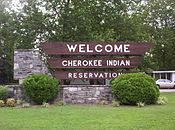
A sign reading Qualla Indian Reservation , erected in 1975, contains the following text:
“The Cherokee domain once extended far beyond the distant mountains, but the white man, with broken treaties and fruitless promises, brought trouble to the Indians and caused their banishment to an Oklahoma reservation. A few escaped capture and fled into the Great Smokies , eventually forming the Eastern Band that now lives on the Qualla Reservation in the valley below. "
“The Cherokee land once stretched far beyond the distant mountains, but the white man, with broken contracts and fruitless promises, brought suffering to the Indians and caused them to be exiled to the Oklahoma Reservation. A few were able to escape capture and fled to the Great Smokies, they formed the Eastern Band that now lives in the Qualla Reservation in this valley. "
Administration and legislation
The tribal community functions like most other communities, running schools , law enforcement , ambulance services , and their own hospital and casino . Since 1987 the tribe has also had its own court system. The tribal police have exclusive rights in the area of the boundary, only the federal authorities, such as the FBI, are allowed to investigate crimes against the state. Several state law enforcement agencies, such as the North Carolina State Troopers, Ranger, or SBI agents, can be called in by the Tribal Police for assistance. Offenders who are not members of the tribe will be handed over to the local authorities.
In the media
In the mid-1950s, much of the five-part Disney series Davy Crockett was filmed with Fess Parker in the Boundary.
literature
- United States Census Bureau: Eastern Cherokee Reservation, North Carolina
- Thomas Donaldson: Eastern Band of Cherokees of North Carolina 1892, 11th Census of the United States, US Printing Office, Washington, DC.
Web links
Individual evidence
- ↑ NCGenWeb Project | North Carolina Genealogy Resources ( en-US )
- ^ North Carolina Maps: Map of the Qualla Indian Reserve (Boundary) NC
- ↑ a b History & Culture . Archived from the original on April 15, 2015. Retrieved July 9, 2020.
- ↑ NCPedia.org: Qualla Boundary accessed July 9, 2020.
- ^ Anne Mitchell: Culture, History, and Development on the Qualla Boundary in Appalachian Journal and Appalachian State University, 1997, Volume 24 (English)
- ↑ Shea Denning: Criminal Jurisdiction on the Qualla Boundary ( en-US ) July 10, 2019.


