
Quernheim (Kirchlengern)
|
Quernheim
Kirchlengern municipality
|
|
|---|---|
 |
|
| Height : | 100 m |
| Area : | 3.86 km² |
| Residents : | 1542 (Jan. 1, 2007) |
| Population density : | 399 inhabitants / km² |
| Incorporation : | 1st January 1969 |
| Postal code : | 32278 |
| Area code : | 05223 |
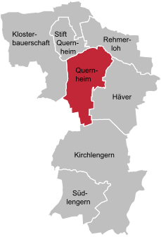  Location of Quernheim in Kirchlengern
|
|
Quernheim is a district of the municipality of Kirchlengern in northeast North Rhine-Westphalia and belongs to the Herford district . Before 1969 Quernheim formed an independent community. With around 1500 inhabitants, Quernheim is the second smallest district in the municipality.
location
Quernheim is located in the north of the East Westphalian municipality of Kirchlengern ( Herford district ) in the Ravensberger Land and is largely agricultural. In a clockwise direction it borders on Klosterbauerschaft , Stift Quernheim , Rehmerloh , Häver , Kirchlengern (all parish of Kirchlengern) and Spradow (town of Bünde ).
history
The name "Quernheim" shows Querneheim as belonging to the women's monastery Quernheim , which has been documented since 1147. The noble von Quernheim family , who once owned manors in the area (Gut Niederbehme, Gut Oberbehme and Ulenburg Castle ), have the place name in their family name. Quernheim (then Quernem ) was in 1150 in the lifting role of Herford first mentioned. At first it belonged to the Minden bishopric , after its secularization to the Principality of Minden . After the Peace of Westphalia in 1648, the area fell to Brandenburg-Prussia and became Lutheran during the Reformation, which it has remained to this day. From 1807 to 1810 Quernheim belonged to the Napoleonic Kingdom of Westphalia , from 1811 to France. In 1813 (officially 1815) it fell back to Prussia.
Until the municipal territorial reform on January 1, 1969, when it was merged with other formerly independent districts to form the new municipality of Kirchlengern, Quernheim was a separate municipality , first in the Gohfeld-Mennighüffen district , then in the Kirchlengern district .
Population development
- 1925: 789 inhabitants
- 1933: 941 inhabitants
- 1939: 981 inhabitants
- 1961: 1188 inhabitants
- 1968: 1411 inhabitants
- 2007: 1543 inhabitants
coat of arms
The coat of arms of the old community of Quernheim shows a silver linden tree with roots in the red field. Quernheim once belonged to the mark of the Frauenstift in Stift Quernheim . The linden tree indicates the logging in the common marrow . This mark was called the Quernheimer Mark Economic Association. The coat of arms of the municipality of Kirchlengern also refers to this symbolism. The wooden court has probably moved to Lengern since the end of the 16th century, but before that the wooden court was held regularly and later irregularly in Quernheim.
The red field indicates the Principality of Minden or the Principality of Minden , to which Quernehim once belonged. A 1000-year-old linden tree in front of the church in Hagedorn, which may have been the model for the coat of arms, was destroyed at the end of the last world war.
Attractions
Quernheim belongs to the Evangelical Church Community of Hagedorn. The local church was built in 1911 from natural stone through a cross-shaped floor plan. Neo-Romanesque style elements paired with Art Nouveau elements decorate the interior. The church replaced the no longer existing old Klus in Quernheim.
The fire brigade museum has been relocated to Häver .
societies
A successful fencing club is the Quernheimer Fechtclub (Quernheimer FC).
Individual evidence
- ↑ Martin Bünermann: The communities of the first reorganization program in North Rhine-Westphalia . Deutscher Gemeindeverlag, Cologne 1970, DNB 456219528 , p. 74 .
Web links
- Coat of arms of the former municipality
- Quernheim (Kirchlengern) in the Westphalia Cultural Atlas