Rábasebes
| Rábasebes | ||||
|
||||
| Basic data | ||||
|---|---|---|---|---|
| State : | Hungary | |||
| Region : | Western Transdanubia | |||
| County : | Győr-Moson-Sopron | |||
| Small area until December 31, 2012 : | Csorna | |||
| District since 1.1.2013 : | Csorna | |||
| Coordinates : | 47 ° 26 ' N , 17 ° 15' E | |||
| Area : | 5.39 km² | |||
| Residents : | 88 (Jan. 1, 2011) | |||
| Population density : | 16 inhabitants per km² | |||
| Telephone code : | (+36) 99 | |||
| Postal code : | 9327 | |||
| KSH kódja: | 20136 | |||
| Structure and administration (status: 2018) | ||||
| Community type : | local community | |||
| Mayoress : | Edit Mizser (independent) | |||
| Postal address : | Széchenyi et al. 2 9327 Rábasebes |
|||
| Website : | ||||
| (Source: A Magyar Köztársaság helységnévkönyve 2011. január 1st at Központi statisztikai hivatal ) | ||||
Rábasebes is a Hungarian community in the county Csorna in Győr-Moson-Sopron County .
Geographical location
Rábasebes is located about 15 kilometers south of the town of Csorna on the left bank of the Rába River . Neighboring municipalities are Vág and Szany, the municipality Kemenesszentpéter is opposite on the other side of the river.
Attractions
- Roman Catholic Church Nepomuki Szent János , built around 1780 (late baroque), the tower was added in 1811
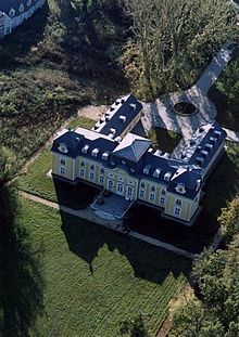
- Széchényi Castle ( Széchényi-kastély ), which Count Jenő Széchenyi had built in the French neo-baroque style at the beginning of the 20th century
traffic
Rábasebes can only be reached via the secondary road No. 84133 from the country road No. 8425, which runs north of the village. The nearest train station is in the northeast in Szany-Rábaszentandrás.
Web links
- Official website ( Hungarian )
- Rábasebes at tourinform.hu (Hungarian)


