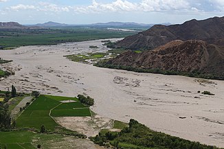
Chicama River
|
Río Chicama, Río Perejil, Río Grande, Río Huancay |
||
|
Flood on the Chicama River |
||
| Data | ||
| location |
|
|
| River system | Chicama River | |
| Headwaters |
Western Cordillera , near the Callacuyán mine 7 ° 58 ′ 33 ″ S , 78 ° 15 ′ 50 ″ W |
|
| Source height | approx. 4160 m | |
| muzzle |
Pacific Ocean Coordinates: 7 ° 56 ′ 32 ″ S , 79 ° 17 ′ 10 ″ W 7 ° 56 ′ 32 ″ S , 79 ° 17 ′ 10 ″ W |
|
| Mouth height | 0 m | |
| Height difference | approx. 4160 m | |
| Bottom slope | approx. 25 ‰ | |
| length | approx. 165 km | |
| Catchment area | approx. 5100 km² | |
| Right tributaries | Río Chuquillanqui , Río Chepino, Río Santa Ana | |
| Small towns | Chicama | |
The Río Chicama is an approximately 165 km long tributary of the Pacific Ocean in northwestern Peru in the regions of La Libertad and Cajamarca .
River course
The Río Chicama rises in the Peruvian Western Cordillera , near the Callacuyán mine, 20 km south of the town of Coina at an altitude of about 4160 m . It initially flows in a predominantly north-westerly direction through the mountains. At river km 90 the Río Chuquillanqui meets the Chicama from the right. The river then turns west. At river kilometer 40, the Río Chicama reaches the coastal plain, which it then crosses in a south-westerly direction. The small town of Chicama is 4 km south of the lower reaches. The Río Chicama finally flows into the Pacific Ocean 33 km northwest of the city of Trujillo . On its way through the mountains, the river repeatedly forms wide alluvial areas that are flooded during floods. In the coastal plain, along the lower course of the river, there are irrigated cultivated areas.
Hydrology
The river carries little water during the dry season in summer. In contrast, it discharges a large part of the annual runoff during the rainy season from January to April. During the El Niño years, the region experiences heavy rain events with the associated flooding events.
Catchment area
The approximately 5100 km² catchment area borders on that of the Río Jequetepeque in the north and that of the Río Moche in the south .
