Río Ranchería
| Río Ranchería | ||
|
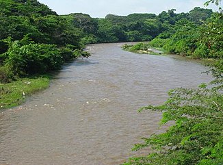
Río Ranchería below the El Cercado dam |
||
| Data | ||
| location |
|
|
| River system | Río Ranchería | |
| Headwaters |
Sierra Nevada de Santa Marta 10 ° 55 ′ 34 ″ N , 73 ° 22 ′ 12 ″ W. |
|
| Source height | approx. 3600 m | |
| muzzle |
Caribbean Sea Coordinates: 11 ° 33 ′ 20 ″ N , 72 ° 54 ′ 20 ″ W 11 ° 33 ′ 20 ″ N , 72 ° 54 ′ 20 ″ W |
|
| Mouth height | 0 m | |
| Height difference | approx. 3600 m | |
| Bottom slope | approx. 14 ‰ | |
| length | approx. 260 km | |
| Catchment area | approx. 4060 km² | |
| Drain |
MQ 1976/1993 |
12.4 m³ / s |
| Reservoirs flowed through | El Cercado dam | |
| Big cities | Riohacha | |
| Medium-sized cities | Fonseca | |
| Small towns | Distracción , Barrancas , Albania | |
|
Río Ranchería near the city of Fonseca |
||
|
Estuary at Riohacha |
||
The Río Ranchería is an approximately 260 km long tributary of the Caribbean Sea in Colombia .
River course
The course of the Río Ranchería is located in the La Guajira department in the extreme northeast of Colombia. The Río Ranchería rises in the northeast of the Sierra Nevada de Santa Marta at an altitude of about 3600 m . It initially flows 30 km in an east-northeast direction through the mountains. The first 20 km are within the Parque Nacional Natural Sierra Nevada de Santa Marta . Then it turns towards east-southeast and cuts through a foothill of the mountain range. The Río Ranchería is dammed at river kilometer 205 by the dam El Cercado over a length of 6 km. Below the dam, the river turns east. It passes the cities of Distracción and Fonseca . The river then turns to the northeast and flows through a valley that separates the Sierra Nevada de Santa Marta in the west from the Sierra de Perijá in the east. In the valley are the cities of Barrancas and Albania on the river. Very close to the Río Ranchería is the mine El Cerrejón , in which opencast coal is mined. North of Albania at river kilometer 100 the Río Ranchería reaches the coastal lowlands. The river now turns 50 km to the northeast. For the last 50 km, the Río Ranchería flows west-northwest. Eventually it reaches the sea on the northeastern edge of the city of Riohacha . 4 km above the estuary, an estuary branches off to the north.
Hydrology
The Río Ranchería drains an area of about 4060 km². In the lower reaches of the Río Ranchería flows through a region with relatively little rainfall. The mean discharge is only 12.4 m³ / s. Near the mouth of the river, the river usually only carries a small amount of water.
Web links
Individual evidence
- ^ A b Juan D. Restrepo, Björn Kjerfve: The Pacific and Caribbean Rivers of Colombia: Water Discharge, Sediment Transport and Dissolved Loads . Hydrochemical Aspects of Major Pacific and Caribbean Rivers of Colombia. January 2004. Retrieved March 15, 2019.


