Roman manor of Homberg
The Roman manor of Homberg is a former villa rustica , a Roman manor from the 1st century, which existed until at least the 3rd century.
location

The facility in the eastern part of the Hegau comprised five buildings on an area of 5.4 hectares (200 × 270 m). You are at an altitude of about 560 m above sea level. NHN in Won "Dammbühl", approximately 2.7 kilometers northeast of the community Eigeltingen and 400 meters southwest of the hamlet Homberg in Baden-Württemberg district of Konstanz in Germany .
Excavations
The first indications of a villa rustica come from the main teacher Nikodemus Gertis, who worked in Mahlspüren, in 1901, he mentioned wall remains, fragments of ceramics and bricks. Further evidence from the late 1920s was followed by the first excavations from 1935 to 1937 . The wall surrounding the estate was found to be around 940 meters (200 × 270 m) long.
In 1989, further details were precisely localized through aerial photographs taken by the Baden-Württemberg State Monuments Office .
The attachment
With an area of 5.4 hectares, the property is one of the largest manors in Baden-Württemberg. In addition to the family that owned it, it was probably also inhabited by servants and craftsmen and resold the surpluses generated to supply the Vici population, especially the nearby Vicus Orsingen , and the military.
Main house
The south-east facing, representative and almost 4200 square meters (at least 70 × 60 m) large main house stood on the highest point of the "Dammbühl". It had tower-like projections at the corners of the entrance hall ( porticus ), which was presumably supported by columns, and an open inner courtyard, which was delimited by side wings that reveal several rooms.
Outbuildings
To the east of the main house is a bath house, in the wall surrounding the manor in the south-east there is evidence of a gate building. The function of three other, not yet excavated buildings is not yet known.
Finds
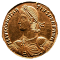
A gold multiplum was found outside the courtyard wall in the 1930s . Multipla have been minted since the reign of Augustus as a gift ( donativum ) to special dignitaries, since the rule of Gallienus also as pay to officers and from the end of the fourth century onwards also to pay tribute to Germanic peoples.
The front of the found multiplum shows the bust of Constantius II , son of Constantine the Great and after his death from 337 emperor in the east of the Roman Empire and from 353 emperor of the entire Roman Empire. On the back is Tyche , the goddess of fate in Greek mythology . The multiplum dates back to the time after the Limes fall between 341 and 354 AD.
Monument protection
The ground monument "Römischer Gutshof von Homberg" is protected as a registered cultural monument within the meaning of § 2 of the Monument Protection Act of the State of Baden-Württemberg (DSchG) . Investigations and targeted collection of finds are subject to approval, and accidental finds are reported to the monument authorities.
See also
- Roman estate of Eigeltingen , about one kilometer to the southwest
- List of Villae rusticae
literature
- Jürgen Hald, Gerd Stegmaier, Alexandra Zimmer: New investigations in the Roman estate of Eigeltingen, Constance district . In: Archaeological excavations in Baden-Württemberg 2001 . Konrad Theiss, Stuttgart 2002. ISBN 3-8062-1659-2 , pp. 130-133.
- Jürgen Hald and Wolfgang Kramer on behalf of the Hegau History Association (ed.): Archaeological treasures in the Konstanz district . Michael Greuter, Hilzingen 2011, ISBN 978-3-938566-15-2 .
- Jürgen Hald, Harald Derschka : Relics of a Battle? New late antique finds from Eigeltingen-Münchhöf . In: Martin Kemkes et al. (Ed.): Ob res prospere gestas. Because of successfully executed deeds. Festschrift for Jörg Heiligmann . Likias, Friedberg 2018, pp. 172-185, ISBN 978-3-9817006-8-8 .
Web links
- Information board " The Römische Gutshof von Homberg " on the website of the "Förderverein Römischer Gutshof in Eigeltingen e. V "
Individual evidence
- ↑ Top25 Viewer - Topographic Map 1: 25000 Baden-Württemberg (South).
- ↑ Information board " The Roman manor of Homberg " in the outdoor area.
- ^ Claudia Theune : Teutons and Romanes in the Alamannia: structural changes due to the archaeological sources from the 3rd to the 7th century . Walter de Gruyter, Berlin / New York 2004, ISBN 3-11-017866-4 , pp. 423-430, here p. 427.
- ↑ Albert Bittlingmaier: Old walls tell stories. August 22, 2008. Retrieved July 19, 2013 .
Coordinates: 47 ° 52 '24.2 " N , 8 ° 55' 35.4" E
