Germania superior

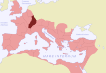
Germania superior ("Obergermanien") was a Roman province on the Upper Rhine , which existed at the latest from the year 90 until the end of the 3rd century, when the area was divided into two provinces. Roman rule on the Upper Rhine ended in the 5th century . The Germania superior , in which strong troops were stationed, comprised parts of what is now Switzerland , France and southwestern Germany (especially the Dekumatland ). The province bordered Germania inferior ("Niedergermanien", later Germania secunda ) on the Lower Rhine in the north, Gallia Belgica and Gallia Lugdunensis in the west, Gallia Narbonensis in the southwest and Raetia in the southeast . East of the province was Germania magna (the "free" Germania). The governor's seat of the province was in Mogontiacum , today's Mainz .
history
Roman province
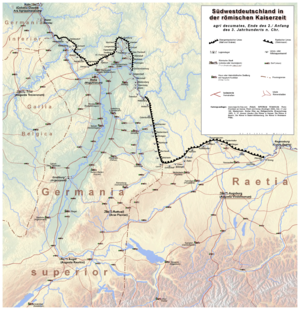
With the Augustan campaigns from 13/12 BC The areas on the left bank of the Rhine came under Roman control. Until the founding of the province, which was completed by 90 at the latest, the area on the Upper Rhine was administered militarily (exercitus superior) . In the 2nd century in particular, the area on the right bank of the Rhine and the advancement of the Limes led to significant enlargements of the province (Dekumatland), which, with a total area of 93,500 km², belonged to the medium-sized provinces of the Roman Empire. The importance of the province, however, was not due to its size, but to its location on an endangered border of the empire, which is why it was strongly dominated militarily. The commander of the troops stationed in Upper Germany therefore represented a considerable power factor, especially in the 1st and 2nd centuries, as he could reach Italy relatively quickly with the Rhine legions. For example, Vitellius, the commander of the Lower Germanic military district, moved to Rome in the civil war of the Four-Emperor's year 69 after the troops of Upper Germania had joined him, and many historians assume that Trajan was only appointed as his successor by Emperor Nerva in 97 because at that time he commanded the Upper German Army.
Division of the province
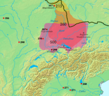
Between 260 and 280 the Dekumatland was evacuated by the Roman troops ( Limesfall ) and the military border was moved back to Rhenus ( Rhine ) and Danubius ( Danube ). Under Emperor Diocletian in late antiquity after 297 the province Germania superior was divided into Germania prima in the north and Maxima Sequanorum in the south and subordinated to the diocese of Gaul with the imperial city of Trier ( Augusta Treverorum ) . Emperor Valentinian I had the border of the province secured with fortresses around 370.
Time of the Great Migration
In 406, Germanic attackers crossed the Rhine during the migration of peoples and plundered several Roman cities. In the early 5th century, Burgundians (411-435) initially controlled the area as foederati together with regular Western Roman units until they rebelled and were bloodily overthrown by Flavius Aëtius in 436. After around 455, the Alamanni and finally the Merovingian Franks succeeded Roman rule on the Rhine: When Clovis I succeeded his father as rex around 482 , he also became formally administrator of the Germania Prima province , which then gradually became the Franconian crown land should.
colonization
Due to its location on the border of the Roman Empire, numerous Roman troops were stationed here. Legions were stationed in Mainz / Mogontiacum, Strasbourg / Argentorate and at times Windisch / Vindonissa , as well as many auxiliary troops on the Upper German Limes .
In addition to the initially dominant military component, a civilian component appeared in the hinterland from the late 1st to the early 3rd century during the peaceful period: a structure in civitates (singular civitas : main places with an associated [tribal] area) took place. On the left of the Rhine, these main towns such as Noviomagus ( Speyer ) and Borbetomagus ( Worms ) represent the oldest German cities. In the area on the right bank of the Rhine, this continuity was less, as Roman rule only lasted until the 3rd century. Some Civitas main locations such as Nida (today: Frankfurt-Heddernheim ) were therefore not continuously populated until the Middle Ages , while in other main locations such as Dieburg , Wiesbaden or Ladenburg a settlement continuity (albeit under simpler circumstances) is likely.
In addition to the main towns and the military camps , there were smaller civilian settlements ( vici ) such as Altiaia ( Alzey ), Eisenberg , Rockenhausen , Groß-Gerau or Heldenbergen . These did not have their own legal status and were assigned to the higher-level Civitas administration. Often they were at crossroads or had a commercial character. The settlement was dominated by numerous Roman country estates ( villae rusticae ) , some of which had considerable luxury. This can be seen, for example, in the Roman Open-Air Museum in Hechingen-Stein . The province benefited from the presence of the Roman army, as the imperial soldiers had considerable purchasing power and the troops were largely dependent on regional agricultural production; villae rusticae was primarily responsible for these . Beyond the Roman cities and country estates, the old Germanic population mostly remained resident, in the Dekumatland, into which numerous immigrants poured, a Celtic-Germanic mixed population lived.
The following Upper Germanic civitates are currently known:
- Civitas Ulpia Sueborum Nicretum (after the Neckarsueben ), main town Ladenburg ( Lopodunum ) ;
- Civitas Alisinensium , main town Wimpfen ;
- Civitas Aurelia G ... main town Cannstatt (presumed);
- Civitas Sumelocennensis , main town Rottenburg (Latin Sumelocenna );
- Civitas Aquensis , main town Baden-Baden (Aquae) ;
- Civitas Vangionum , main town Worms ( Borbetomagus ) ;
- Civitas Nemetum , capital Speyer ( Noviomagus ) ;
- Civitas Mattiacorum , main town Wiesbaden ( Aquae Mattiacorum ) ;
- Civitas Taunensium , capital Frankfurt - Heddernheim ( Nida ) ;
- Civitas Auderiensium , main town Dieburg ( Med ... rest of the name unknown)
- Civitas Helvetiorum , main town Avenches ( Aventicum )
Notable Vici :
- Centum Prata ( Kempraten )
- Turicum ( Zurich )
- Vitudurum ( Winterthur )
- Tabernae ( Rheinzabern )
As the only known settlements Augst ( Augusta Raurica ) and (from 70) Avenches ( Aventicum ) achieved the higher status of a colony , Rottweil ( Arae Flaviae ) that of a municipality . To which civitas the provincial capital Mainz ( Mogontiacum ) belonged, like the legal status of the city itself, is so far unknown. There is speculation as to whether the Aresaks who settled in the area (part of the Treveri tribe ) formed an independent civitas , or whether the area around Mainz was under military administration and thus directly under the governor. How the areas in the northernmost part of the Germania superior - the area around Koblenz ( Confluentes ) - were administratively structured is also unknown.
Governor
literature
- Dietwulf Baatz , Fritz-Rudolf Herrmann (ed.): The Romans in Hessen. 2nd Edition. Theiss, Stuttgart 1989, ISBN 3-8062-0599-X .
- Tilmann Bechert et al. (Ed.): Orbis Provinciarum. The provinces of the Roman Empire. Introduction and overview. Philipp von Zabern, Mainz 1999, ISBN 3-8053-2399-9 , pp. 191-198.
- Maureen Carroll: Romans, Celts and Teutons. Living in the Germanic provinces of Rome . Theiss, Stuttgart 2003, ISBN 3-8062-1762-9 .
- Heinz Cüppers (Ed.): The Romans in Rhineland-Palatinate . Theiss, Stuttgart 1990, ISBN 3-8062-0308-3 .
- Philipp Filtzinger (Ed.): The Romans in Baden-Württemberg. 3. Edition. Theiss, Stuttgart 1986, ISBN 3-8062-0287-7 .
- Philipp Filtzinger: The Romans in Baden-Württemberg. In: Meinrad Schaab , Hansmartin Schwarzmaier (ed.) U. a .: Handbook of Baden-Württemberg History . Volume 1: General History. Part 1: From prehistoric times to the end of the Hohenstaufen. Edited on behalf of the Commission for Historical Regional Studies in Baden-Württemberg . Klett-Cotta, Stuttgart 2001, ISBN 3-608-91465-X .
- Thomas Fischer : The Romans in Germany . Theiss, Stuttgart 1999, ISBN 3-8062-1325-9 .
- Andres Furger: Switzerland at the time of the Romans . Neue Zürcher Zeitung, Zurich 2001, ISBN 3-85823-809-0 .
- Andreas Kakoschke: The personal names in the two Germanic provinces. A catalog . Volume 1. Gentilnomina Abilius - Volusius . Leidorf, Rahden / Westf. 2006, ISBN 3-89646-032-3 . Volume 2.1. Cognomina Abaius - Lysias . Ibid, 2007, ISBN 978-3-89646-033-2 . Volume 2.2. Cognomina Maccaus - Zyascelis. Ibid, 2008, ISBN 978-3-89646-042-4 .
- Margot Klee : Germania Superior. A Roman province in France, Germany and Switzerland . Friedrich Pustet, Regensburg 2013, ISBN 978-3-7917-2367-9 .
- Wolfgang Spickermann : Religious history of Roman Germania. Volume 1: Germania superior . (= Religion of the Roman provinces. Volume 2). Mohr Siebeck, Tübingen 2003, ISBN 3-16-146686-1 .
Web links
- Regula Frei-Stolba : Germania Superior. In: Historical Lexicon of Switzerland .
- Small towns in the province of Germania Superior in the north and south, Museum of Ancient Shipping
Individual evidence
- ^ First inscribed mention of the province in a military diploma dated October 27, 1990 ( CIL 16, 36 ).
- ↑ Angelika Hunold: The Roman vicus of Alzey . (= Archaeological writings of the Institute for Prehistory and Early History of the Johannes Gutenberg University Mainz. Volume 5). Mainz, 1997, ISBN 3-928957-04-X .
- ↑ Helmut Bernhard u. a .: The Roman vicus of Eisenberg. A center for iron extraction in the Northern Palatinate . (= Archaeological monuments in the Palatinate. Volume 1). Germersheim 2008, ISBN 978-3-936113-02-0 .
- ^ Mathias Faul: A previously unknown vicus in the northern Palatinate. In: Reports on archeology in Rheinhessen and the surrounding area. 1. Volume, Mainz 2008, pp. 30-34.
- ^ Carsten Wenzel: Groß-Gerau I. The Roman vicus of Groß-Gerau, "Auf Esch". The building findings of the fort vicus and the settlement of the 2nd – 3rd centuries. Century. (= Frankfurter Archäologische Schriften . 9). Habelt, Bonn 2009, ISBN 978-3-7749-3637-9 .
- ↑ Wolfgang Czysz : Heroes mountains in the Wetterau. Camp, fort, vicus. (= Limes research. 27). Mainz 2003, ISBN 3-8053-2834-6 .
- ↑ Tacitus : Germania 29 ( Latin text ).
- ^ Klaus Kortüm : Cities and small-town settlements. Civil structures in the hinterland of the Limes. In: Imperium Romanum. Rome's provinces on the Neckar, Rhine and Danube. Archäologisches Landesmuseum Baden-Württemberg, Esslingen 2005, ISBN 3-8062-1945-1 , pp. 154-164.
- ↑ C. Sebastian Sommer : The urban settlements in Upper Germany on the right bank of the Rhine. In: Hans-Joachim Schalles (Hrsg.): The Roman city in the 2nd century AD. The functional change of public space. Xanten Colloquium May 2 to 4, 1990 (= Xanten Reports , Volume 2). Rheinland-Verlag, Cologne 1992, ISBN 3-7927-1252-0 , pp. 119-141.
Coordinates: 49 ° N , 8 ° E


