
Dieburg in Roman times
In Roman times, Dieburg wasthe civil administrative center of the Civitas Auderiensium in Upper Germany and the capital of the Limes hinterland on the right bank of the Rhine,south of the Main in today's Hesse . The name of the settlement is only fragmentary (“ Vicus Med ...”).

history
.jpg)
The foundation of the Roman Civitas capital Dieburg is set in Hadrianic times around the year 125 AD. Previously, the rear area south of the Main had been handed over from the military to the civil administration after consolidation of the adjacent Limes stretches of the Main and Odenwald Limes . The event is connected with the abandonment of rear garrisons, especially in Groß-Gerau ( fort "Auf Esch" ), and based on the finds (coin series and the lack of southern Gallic terra sigillata in Dieburg) shortly before the reign of Emperor Hadrian (117-138 ) to be accepted. In contrast to other suburbs in the region such as Wiesbaden ( Aquae Mattiacorum ) , Frankfurt-Heddernheim ( Nida ) , Ladenburg ( Lopodunum ) or Bad Wimpfen , the civil settlement in Dieburg was not preceded by a military camp; at least contrary to assumptions in the earliest research, no evidence of this was found . The place was probably an important intersection before.
The function as a suburb of the Civitas Auderiensium is secured by finds of inscriptions. The civitas is mentioned in two decurion inscriptions from Mainz ( Mogontiacum ) and Heddernheim. It was not until 1924 that the fragment of a very high-quality Jupiter giant column was discovered at the southern exit of Dieburg that Dieburg could be identified as the administrative seat of this civitas. Below the Wochengötterstein was the donor's inscription of the councilor Licinius Ob ...
The finds indicate a heyday of the settlement at the turn of the 2nd to the 3rd century AD. As in medieval Dieburg, there was a particularly strong production of ceramics, including bricks such as what is known in research as the Dieburger Group , characteristic bricks with roller stamp decoration.
Because of the increasing insecurity of the border region, a city wall was built in Dieburg, as in many of the main Civitas towns on the right bank of the Rhine, in the early 3rd century AD. A mithraium north of the settlement was not included in the walling, which may indicate that the fortification was built in a hurry. However, as evidenced by the finds, the Mithras sanctuary was also abandoned at the beginning of the 3rd century, possibly destroyed, as Egon Schallmayer suspected, during an Alemannic invasion in 233. The emperor Maximinus Thrax , who was raised in 235, had the city wall built as part of the resulting Germanic war when the sanctuary was no longer in use.
The ancient Dieburg was finally given up with the Limes Falls in AD 259/260.
Place name

The ancient name of Dieburg has not been fully established to this day. The discovery of an altar with dedicatory inscription from Rittergasse mentions the genius of Vicus V (---) V (---). This was mostly resolved as Vicus Vetus Ulpius , combined with the assumption that the place was founded under Emperor Trajan and received his proper name. Today it is assumed that only part of the settlement is hidden behind this name.
A Leugenstein found near Kleestadt suggests that the place name begins with M, as these stones were mostly set by the local Civitas administration. The inscription is unfortunately broken off in the line with the mention of the place name. A distance of four leagues to Dieburg can be reconstructed on the basis of the site .
The so-called dendrophoric inscription from the neighboring Civitas capital Nida-Heddernheim mentions that this priesthood ( Magna Mater - or Kybele cult) together with that of the village Med (...) built a meeting house in Nida . This is interpreted as a mention of the Dieburg place name, although further completion of the name or an etymological interpretation is currently not possible.
City layout
The Roman settlement stretched between Dieburger Bahnhof , Minnefelder Seestrasse in the north, Ringstrasse in the east and south and Steinstrasse in the west. It was therefore much larger than the medieval Dieburg. The location near today's old town has led to extensive overbuilding since the Middle Ages, so that the Roman city map can only be reconstructed with large gaps. The residential buildings are likely to have consisted of typical Roman strip houses , some of which were excavated in the street An der Altstadt . A rectangular building floor plan with a hypocaust at the tax office in Marienstraße, on the other hand, looks more like an insula development. A pottery furnace was found in the area of the Marienschule.
basilica
West of Theobaldstrasse , during an excavation in 1893, large, regularly hewn sandstone blocks were found, which were laid on a roller layer over a length of 50 m . They had wolf holes and were connected by iron brackets. A single, 17.2 × 9.6 m, partially hypocausted room suite was excavated between the foundations. The dimensions of the structure and its location in the center suggest an official official building, probably a market basilica . The building is likely to have been built around the time the civitas was established.
city wall
The city wall that was built in the early 3rd century - according to Egon Schallmayer after 235 as a result of Germanic incursions - could be cut in the north, east and south of the city. It included an area of 23 hectares. In 1972 the foundation in the southern ring road was exposed over a length of 67 m. It had a width of 1.60 m. At the eastern entrance to the city from “Hohen Strasse”, a pavement and the upstream ditch profile were observed decades earlier. The sandstone slabs (70 × 40 cm) found there were probably used as tin ceilings.
Sanctuaries
Mithraea
North of the city wall was 1,926 at the Minne fields Seestraße a Mithraeum excavated. It was oriented in a west-east direction and corresponded to the well-known, long rectangular floor plan of such systems. On the long sides there were couches ( Klinen ), a block of wall on the western narrow side served as the foundation for the rotatable cult image. One entered the altogether about 20 m long sanctuary through a wooden vestibule, which was built on the east side.
The finds from Mithraeum, which was probably destroyed at the beginning of the 3rd century, are particularly numerous and of high quality, including 22 fragments of sculptures and reliefs. The cult image, which shows scenes from the Phaethon saga in the medallion field, is outstanding . There is a largely identical cult image from the neighboring Stockstadt Fort , both of which are likely to have come from the same workshop.
A second Mithraeum can be assumed due to the somewhat older discovery of another cult image fragment depicting the week gods.
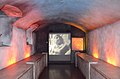
Reconstructed Mithraeum in the Museum Schloss Fechenbach

Front of the cult image

Fragment of another cult image
.jpg)
.jpg)
.jpg)
.jpg)
Temple precinct
East of the intersection of Aschaffenburger and Groß-Umstädter Strasse , a larger complex was excavated in 1977/78, but no coherent floor plan could be determined. An angled wall with an almost square building and another foundation , possibly a Gallo-Roman temple , suggests a cult area in the periphery of the settlement. A fully preserved cult tableware supports this interpretation. It refers to an oriental cult, but the gods worshiped here cannot be narrowed down. A small treasure trove was deposited in the 60s of the 2nd century AD, possibly the complex was affected by the first chat incursions of this time.
.jpg)
Burial grounds
So far, six grave fields have been identified, from which 211 graves were recovered by the end of the 1980s. The grave fields were each on the arterial roads in front of the city. Cremations are predominant. With 125 graves examined, the grave field on the road leading to Groß-Umstadt was the largest of these. Most of the graves are dated between 140 and 200 AD. The earliest grave comes from the second largest burial ground north of the city and dates between 120 and 130 AD.
Surrounding area
In contrast to the neighboring Civitas Taunensium to the north , which comprised the fertile areas of the Wetterau, rural settlement in the Dieburger Bucht started a little later than there around 120 AD. Since that time, numerous villae rusticae have been built in the area around the city and into the valleys of the Vorderen Odenwald . Well-known and excavated structures of this type were among others at Ober-Ramstadt , Semd , under the Evangelical parish church Groß-Umstadt and already on a hill in the Odenwald the Wamboltsche Schlösschen . The most important and most excavated complex of this type is the Roman Villa Haselburg , which is believed to have belonged to a Dieburg councilor.
Dieburg benefited from a favorable location at a traffic junction in the hinterland of the Limes. The most important connection was a street coming from Klein -zimmer , which connected Dieburg with the Rheinhafen Gernsheim and the local Rheintalstraße . Its continuation to the northeast led to the Limes to the Seligenstadt fort . An Altstrasse called Hohe Strasse connected Dieburg with the fort towns on the southern Main Limes. Its further course northwest of the Roman settlement is particularly well preserved between Münster and Urberach , where it represented a direct connection between the main towns of Dieburg and Heddernheim. A direct connection to the south led via Groß-Umstadt into the Mümlingtal , the Odenwald and the Limes forts there. In addition to the Roman roads, the Gersprenz was particularly important as a transport route. Finds such as a boat's hook in Groß-Bieberau indicate that the small river was used far into the valleys of the front Odenwald.

Lost and found and museum
Early finds from Dieburg were mostly handed over to the Hessisches Landesmuseum Darmstadt . The discovery of the rotatable Mithras cult image in 1926 gave rise to the establishment of a Dieburg museum. It has been located in Fechenbach Castle since 1951 and was called the District and City Museum for decades . After a major renovation in 2007, it was named Museum Schloss Fechenbach .
The museum has an archaeological section in the basement with prehistoric and early historical finds and focus on the Roman Dieburg. In addition to the Mithraeum, stone monuments and objects from everyday culture are shown.
literature
- Krešimir Matijević , Rainer Wiegels : Inscriptions and consecration monuments of the Roman Dieburg. In: Saalburg-Jahrbuch 54, 2004, pp. 197-274.
- Egon Schallmayer : The Odenwald Limes. Along the Roman border between the Main and Neckar. Konrad Theiss Verlag, Stuttgart 2010, ISBN 978-3-8062-2309-5 , pp. 53-56.
- Egon Schallmayer: Excavations on the settlement wall of the Roman Civitas main town MED (---) / Dieburg. New reflections on their chronology and historical classification. In: Find reports from Hessen 46/47, 2006/07, pp. 107–168.
- Egon Schallmayer: Dieburg DA. Roman civil settlement MED (...), capital of the Civitas Auderiensium. In: Dietwulf Baatz , Fritz-Rudolf Herrmann (Hrsg.): The Romans in Hessen . 3rd edition, licensed edition Nikol, Hamburg 2002, ISBN 3-933203-58-9 , pp. 250-256.
- Egon Schallmayer: On the Roman name of Dieburg. In: Germania . 59/2, 1981, pp. 307-319.
- Egon Schallmayer: The Roman Dieburg and its grave fields. City of Dieburg, Der Magistrat, 2018, ISBN 978-3-941823-25-9 .
- C. Sebastian Sommer : The urban settlements in Upper Germany on the right bank of the Rhine. In: Hans-Joachim Schalles (Hrsg.): The Roman city in the 2nd century AD. The functional change of public space. Xanten Colloquium May 2 to 4, 1990 (= Xantener Reports , Volume 2) Rheinland-Verlag, Cologne 1992, ISBN 3-7927-1252-0 , pp. 119-141.
- Bernd Steidl : Limes World Heritage: Rome's border on the Main (= exhibition catalogs of the State Archaeological Collection. 36). Logo, Obernburg am Main 2008, ISBN 3-939462-06-3 , p. 36f .; 76f .; 102f.
- Georg Wiesenthal: Period of Roman rule. In: Werner Jorns : New land documents from Starkenburg . Bärenreiter, Kassel 1953, pp. 112–145, especially pp. 120–122.
Web links
Individual evidence
- ↑ a b Helmut Castritius , Manfred Clauss , Leo Hefner: The Roman stone inscriptions of the Odenwald (RSO). Contributions to the investigation of the Odenwald 2, 1977, pp. 237-308, no. 157.
- ↑ a b c Egon Schallmayer , in: D. Baatz, F.-R. Herrmann (Ed.): The Romans in Hessen. P. 250.
- ↑ Klaus Kortüm : On the dating of the Roman military installations in the Upper German-Raetian Limes area. In: Saalburg yearbook. 49, 1998, pp. 5-65, here: p. 33.
- ↑ C. Sebastian Sommer : The urban settlements in Upper Germany on the right bank of the Rhine. In: Hans-Joachim Schalles (Hrsg.): The Roman city in the 2nd century AD. The functional change of public space. Xanten Colloquium May 2 to 4, 1990 (= Xanten reports. 2). Rheinland-Verlag, Cologne 1992, ISBN 3-7927-1252-0 , pp. 119–141, here: p. 120; Bernd Steidl: Limes World Heritage: Rome's border on the Main. Logo, Obernburg am Main 2008, p. 102f.
- ↑ CIL 13, 7063 .
- ↑ CIL 13, 07353 (4, p 125)
- ↑ Dietwulf Baatz : Cladding tiles with roller stamp patterns from southern Hesse . In: Saalburg yearbook. 44, 1988, pp. 65-83.
- ^ Egon Schallmayer, in: D. Baatz, F.-R. Herrmann (Ed.): The Romans in Hessen. P. 252f.
- ↑ Egon Schallmayer: Excavations on the settlement wall of the Roman Civitas capital MED (---) / Dieburg. New reflections on their chronology and historical classification. In: Find reports from Hessen. 46./47. Volume, 2006/2007 (published 2010), pp. 107–168; to support this thesis see also Egon Schallmayer: “Before the gates of the city”. A Roman bronze cauldron from Dieburg. In: Find reports from Hessen. Volume 50, 2010 (published 2012), pp. 595–606.
- ↑ CIL 13, 6433 .
- ^ Egon Schallmayer, in: D. Baatz, F.-R. Herrmann (Ed.): The Romans in Hessen. Pp. 250-252.
- ↑ CIL 13, 9121
- ^ Egon Schallmayer: On the Roman name of Dieburg. In: Germania. 59/2, 1981, pp. 307-319, here p. 319.
- ^ Egon Schallmayer , in: D. Baatz, F.-R. Herrmann (Ed.): The Romans in Hessen. P. 252.
- ↑ a b c Egon Schallmayer , in: D. Baatz, F.-R. Herrmann (Ed.): The Romans in Hessen. P. 253.
- ↑ C. Sebastian Sommer: The urban settlements in Upper Germany on the right bank of the Rhine. In: Hans-Joachim Schalles (Hrsg.): The Roman city in the 2nd century AD. The functional change of public space. Xanten Colloquium May 2 to 4, 1990 (= Xanten reports. 2). Rheinland-Verlag, Cologne 1992, ISBN 3-7927-1252-0 , pp. 119–141, here: p. 140.
- ↑ Description based on Egon Schallmayer, in: D. Baatz, F.-R. Herrmann (Ed.): The Romans in Hessen. P. 252f .; on Mithraeum see Friedrich Behn : Das Mithrasheiligtum zu Dieburg. De Gruyter, Berlin and Leipzig 1928 (= Roman-Germanic research 1).
- ^ Marion Mattern: Roman stone monuments from Hesse south of the Main and from the Bavarian part of the Main Limes (= Corpus Signorum Imperii Romani Germany. Vol. 2.13). Verlag des Römisch-Germanisches Zentralmuseums, Mainz, on commission from Habelt, Bonn 2005, ISBN 3-88467-091-3 , p. 29.
- ↑ Marion Mattern: Roman stone monuments from Hesse south of the Main and from the Bavarian part of the Main Limes (= Corpus Signorum Imperii Romani . Germany. Vol. 2.13). Verlag des Römisch-Germanisches Zentralmuseums, Mainz, on commission from Habelt, Bonn 2005, ISBN 3-88467-091-3 , p. 28, cat. No. 81–86 (Stockstadt), no. 272–293 (Dieburg).
- ↑ Maria Porzenheim and Egon Schallmayer: The Roman temple district with cult dishes of Dieburg, Darmstadt-Dieburg. In: Festschrift for Günter Smolla (= materials on the prehistory and early history of Hesse. 8). Wiesbaden 1999, pp. 539-596.
- ^ Egon Schallmayer, in: D. Baatz, F.-R. Herrmann (Ed.): The Romans in Hessen. P. 255. The printing of Schallmayer's dissertation (The Roman Dieburg and its grave fields) in the series Materialhefte on Hessian prehistory and early history has been in preparation for a long time according to the information given there.
- ^ RH Schmidt: The Villae Rusticae "Ober der Pfingstweide" in Ober-Ramstadt, Darmstadt district and "Am Zahl" in Roßdorf, Darmstadt district (= Ober Ramstädter Hefte 2). Ober-Ramstadt 1971; Egon Schallmayer, in D. Baatz, F.-R. Herrmann (Ed.): The Romans in Hessen. Pp. 459-461.
- ↑ Archaeological and Folklore Working Group of the Museum in Dieburg eV (Ed.): Witnesses of the Past. Prehistory, Roman times, Middle Ages in the Dieburger Land, depicted on the basis of the finds from 1970-1980. Dieburg 1980, p. 55; Find reports from Hessen 8, 1968, p. 98; 26/1, 1986, p. 392.
- ^ Egon Schallmayer, in D. Baatz, F.-R. Herrmann (Ed.): The Romans in Hessen. P. 328f .; W. Boss: The Romans in Groß-Umstadt - villa rustica - "city church". In: Magistrat der Stadt Groß-Umstadt (Ed.): 743 - 1993 Groß-Umstadt. Horb 1993, pp. 51-54; Find reports from Hessen 8, 1968, p. 97; 9/10, 1969/70, pp. 173f.
- ↑ Bernd Steidl: Limes World Heritage: Rome's border on the Main (= exhibition catalogs of the State Archaeological Collection 36). Logo, Obernburg am Main 2008, ISBN 3-939462-06-3 , pp. 117f .; Egon Schallmayer: The Odenwald Limes. Along the Roman border between the Main and Neckar. Konrad Theiss Verlag, Stuttgart 2010, ISBN 978-3-8062-2309-5 , p. 56; Dietwulf Baatz, in: D. Baatz, F.-R. Herrmann (Ed.): The Romans in Hessen. Pp. 360-362.
- ^ Egon Schallmayer, in: D. Baatz, F.-R. Herrmann (Ed.): The Romans in Hessen. P. 255.
- ^ Martin Eckoldt: Shipping around the Odenwald. In: The Odenwald. Journal of the Breuberg Association . 1, 1989, pp. 3-18, especially p. 14.
Coordinates: 49 ° 53 ′ 57.6 " N , 8 ° 50 ′ 44.6" E