Rabensdorf
|
Rabensdorf (district) locality cadastral community Rabensdorf |
||
|---|---|---|
|
|
||
| Basic data | ||
| Pole. District , state | Feldkirchen (FE), Carinthia | |
| Judicial district | Feldkirchen | |
| Pole. local community | Feldkirchen in Carinthia | |
| Coordinates | 46 ° 42 '56 " N , 14 ° 4' 58" E | |
| Residents of the village | 191 (January 1, 2020) | |
| Building status | 54 (2001) | |
| Area d. KG | 4.03 km² | |
| Statistical identification | ||
| Locality code | 00600 | |
| Cadastral parish number | 72327 | |
| Counting district / district | Rabensdorf (21002 005) | |
| Source: STAT : index of places ; BEV : GEONAM ; KAGIS | ||
Rabensdorf is a village and at the same time a district and a cadastral community of Feldkirchen in Carinthia with around 200 inhabitants. The village is located in the southwest of the municipality.
history
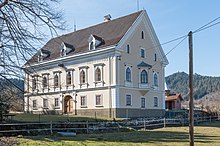
Rabensdorf emerged under the name Radmannsdorf from a medieval aristocratic seat. In 1215 Abbot Konrad von Ossiach awarded the knight ( miles ) Hermannus von Radmarsdorf, a ministerial of the Ossiach monastery , a hat in the former Buchenscheider Moor. Around 250 years later, Rabensdorf was a sovereign fiefdom , as from one of Emperor Friedrich III. issued document from the year 1460, which awarded the property Mert von Dietrichstein. After several changes of ownership, the manor house went downhill in the 18th century, both economically and structurally, even though the building was still referred to as a castle in 1860. The property passed into rural hands and is now used as an inn.
When the self-governing bodies of the municipalities were created in Carinthia after 1848, Rabensdorf was initially a cadastral municipality in the larger municipality of Feldkirchen. In 1894 the cadastral communities of St. Ulrich, Tschwarzen, Waiern and Rabensdorf merged and together they formed the local community of Waiern. In the course of a community reform, this was finally dissolved again by a resolution of the state parliament on January 1, 1964 and incorporated into Feldkirchen.
Buildings and monuments
The so-called Rabensdorf Castle (formerly: Radmannsdorf ), which was still called in the 19th century, is a little spectacular building with unadorned facades and modernized windows. Its former use as a small aristocratic seat can no longer be seen from the outside, only the massive vaults resting on pillars of some of the interior rooms reveal its old age and its former function. In the 17th century the property was still a moated castle , surrounded by a large pond and only accessible via a wooden bridge.
On the so-called Galgenbühel on Kunitzberg is the listed ruin of the former high court. The place of execution of the former Himmelberg district court had high jurisdiction from 1571. Only a 1.90 m high wall ring made of quarry stone can be seen of the building. This ring has a diameter of about 6 meters.
Infrastructure
The 211 inhabitants (as of 2001 census) are spread over around 50 buildings, which are mainly located along the L49 state road. The L49 connects Feldkirchen with Ossiach and the south bank of the Ossiacher See .
Rabensdorf is connected to local public transport via the post bus route 5200 Feldkirchen - Ossiach - Villach.
The Feldkirchen / Ossiachersee airfield (LOKF) is located southwest of the village and is operated by the Feldkirchen Ossiachersee aviation club .
Individual evidence
- ^ History of the former aristocratic residence: Entry about Rabensdorf (Radmannsdorf) on Burgen-Austria
- ^ Dehio Kärnten , Vienna 2001, p. 658.
- ↑ Local directory 2001 - Carinthia , Statistics Austria ( Memento of the original from August 14, 2009 in the Internet Archive ) Info: The archive link has been inserted automatically and has not yet been checked. Please check the original and archive link according to the instructions and then remove this notice. (PDF)
- ↑ Flugsportverein Feldkirchen Ossiachersee


