Racing earth
|
Racing earth
Community Iserlohn
Coordinates: 51 ° 19 ′ 34 ″ N , 7 ° 37 ′ 19 ″ E
|
||
|---|---|---|
| Height : | 370 m | |
| Postal code : | 58769 | |
| Area code : | 02352 | |
|
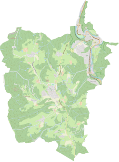
Location of Rennerde in Nachrodt-Wiblingwerde |
||
|
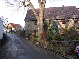
View in Rennerde
|
||
Rennerde is a district of the municipality Nachrodt-Wiblingwerde in the Märkisches Kreis in the administrative district of Arnsberg in North Rhine-Westphalia ( Germany ).
Location and description
The hamlet is located north of the hilltop village of Wiblingwerde on the plateau between the Lasbecker Bach , a tributary of the Lenne , and the Lennetal itself. The L692 state road runs past the village. There is a 210 year old linden tree in a courtyard, which is protected as a natural monument.
In addition to Wiblingwerde, neighboring locations are the locations and residential areas Bramberg , Semberg , Deierte , Roland , Hartmoll , Eilerde , Kreinberg , Becke , Brantenhahn , Höchsten , Nordhelle , Schmalsgotte , Einsal , Obstfelderstall , Westersiepen , Hardt , Steinwinkel , Holensiepen and Nachrodt with Langenstück and Haus Nachrodt in the Lennetal.
History and origin of name
Racing Earth first appeared in 1573 in a document in evidence, as the wooden judge the Lenner Mark Johann to Renförden the three courtyards Obernstrasse , Middern- and Niedern racing world called, the core of today, grown by divisions hamlet.
The appellative in the place name is probably derived from Förde (= ford ). Given the altitude, a ford is not directly used as an eponymous name, so Bleicher suspects in connection with the determinant Renn an interpretation as a path to the ford , passage to the ford or access to the ford in the Lennetal, whereby he as an etymological analogue Rennweg , a path to fast Riding, pulls up. Ultimately, the meaning of the place name could be Fast Path to the Ford .
Further mentions are Renfordt (1693), Renfurt (1694), Renfoerde (1701), Renevorde (1704), Renvorde (1721), Rennerde (1738–42), Renfordt (1740) and from 1810 Rennerde .
On the hand cracks (mensal sheets) for the map of the county of Mark von Eversmann , the place is labeled as Renfort around 1795 . It is continuously recorded as racing earth on the Prussian first recording from 1839 and from the Prussian new recording from 1892 on the TK25 measuring table .
Until the 19th century, Rennerde belonged to the parish , office , recipe and district court Altena of the county of Mark , in 1818 the place had 53 inhabitants. From 1816 the place was part of the school district Wiblingwerde of the tax community Wiblingwerde of the rural mayor's office Altena in the district of Altena , in 1818 24 inhabitants lived in the place. The place, categorized as homesteads according to the location and distance table of the government district of Arnsberg , had ten residential houses and two agricultural buildings in 1839. At that time 63 residents lived in the place, all of them evangelical denominations.
The municipality and district statistics of the province of Westphalia in 1871 list the place with 16 houses and 122 inhabitants. The municipality lexicon for the province of Westphalia in 1885 gives a number of 125 inhabitants for Rennerde who lived in 15 houses. In 1895 the place had 18 houses with 128 inhabitants, in 1905 20 houses and 143 inhabitants are given.
On April 1, 1907, the municipalities of Wiblingwerde and Kelleramt were combined to form the municipality of Nachrodt-Wiblingwerde, which made Rennerde what is now the municipality.
The family name Renfordt comes from this village.
Web links
Individual evidence
- ↑ Märkischer Kreis: Natural Monuments (Rennerde 5) Retrieved on May 8, 2020.
- ↑ a b c Wilhelm Bleicher: On the interpretation of some place names in the municipality of Nachrodt-Wiblingwerde . In: Altena. Contributions to local and regional studies . Heimatbund Märkischer Kreis, Nachrodt-Wiblingwerde 1984, p. 184-190 .
- ↑ a b Johann Georg von Viebahn : Local and distance table of the government district Arnsberg, arranged according to the existing state division, with details of the earlier areas and offices, the parish and school districts and topographical information. Ritter, Arnsberg 1841.
- ↑ Royal Statistical Bureau Prussia (ed.): The communities and manor districts of the Prussian state and their population . The Province of Westphalia, No. IX . Berlin 1874.
- ↑ Royal Statistical Bureau (Prussia) (ed.): Community encyclopedia for the province of Westphalia, based on the materials of the census of December 1, 1885 and other official sources, (community encyclopedia for the Kingdom of Prussia, Volume X), Berlin 1887.
- ↑ Königliches Statistisches Bureau (Prussia) (Ed.): Community encyclopedia for the province of Westphalia, based on the materials of the census of December 1, 1895 and other official sources, (community encyclopedia for the Kingdom of Prussia, Volume X), Berlin 1897.
- ↑ Königliches Statistisches Bureau (Prussia) (Ed.): Community encyclopedia for the province of Westphalia, based on the materials of the census of December 1, 1905 and other official sources, (community encyclopedia for the Kingdom of Prussia, Volume X), Berlin 1909.


