Hallenscheid
|
Hallenscheid
Community Iserlohn
Coordinates: 51 ° 18 ′ 32 ″ N , 7 ° 37 ′ 49 ″ E
|
||
|---|---|---|
| Height : | 315 m | |
| Postal code : | 58769 | |
| Area code : | 02352 | |
|
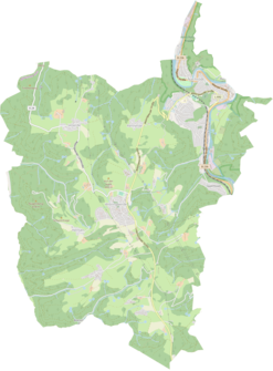
Location of Hallenscheid in Nachrodt-Wiblingwerde |
||
|
Courtyard in Hallenscheid
|
||
Hallenscheid is a district of the municipality Nachrodt-Wiblingwerde in the Märkisches Kreis in the administrative district of Arnsberg in North Rhine-Westphalia ( Germany ).
Location and description
The hamlet is located east of the hill village of Wiblingwerde in a basin between the Hallenscheider Bach and the Opperhusener Bach , a tributary of the Lenne .
In addition to Wiblingwerde, neighboring locations are the locations and residential areas of Opperhusen , Eilerde , Helbecke , Stübbecken , Kreinberg , Buchholz , Eickhoff , Voßnocken , Neuenhaus , Sassenscheid and Neusassenscheid .
The Tannenhof Tacke , an agricultural and forestry business for the ecological cultivation of Christmas trees, is located in the village .
history
Hallenscheid was first mentioned in 1737 as Hollenschedt . While the appellative in the place name is a typical representative of the -scheid place-name , the meaning of the defining word halls has not been clarified without being contradicted. The Evingser homeland and name researcher Hans Dieter Schulz sees a reference to Hale , Hellen and Hel , which are supposed to designate a piece of land in damp, moor-like or swampy terrain.
Other mentions are Hallenschedt (1762) and Haldenscheid (1768).
On the hand cracks (mensal sheets) for the map of the county of Mark von Eversmann , the place is labeled as Hallenscheidt around 1795 . It is continuously recorded as Hallenscheid on the Prussian first recording from 1839 and from the Prussian new recording from 1892 on the TK25 measuring table .
Until the 19th century, Hallenscheid belonged to the parish , office , recipe and district court of Altena of the County of Mark and was divided into the arable farms Obern Hallenscheid and Unter Hallenscheid. In the local dialect the homesteads were called Holsche . The owner families had the surnames Hollenscheid or Hallenscheid after the farm name.
Around 1700, Friedrich Hallenscheid, owner of the two farms, divided his property into two parts and bequeathed them to his two sons.
From 1816 the place was part of the school district Wiblingwerde of the tax community Wiblingwerde of the rural mayor's office Altena in the district of Altena , in 1818 24 inhabitants lived in the place. The place, categorized as a farm according to the location and distance table of the government district Arnsberg , had three houses and two agricultural buildings in 1839. At that time, 22 residents lived in the village, all of whom were evangelicals.
Obern Hallenscheid was acquired in 1842 by Peter Caspar Brinker, who has been called Brinkerhof since then . The last Hallenscheid on the farms was Johann Heinrich zu Hallenscheid (* 1777), whose daughter Anna Katharina Gertrud was married to Caspar Friedrich Grennigloh for the first time and to Hermann Heinrich Lehnhoff zu Wörden for the second time from 1836 . Their descendants now run the Tannenhof Tacke.
The municipality and estate district statistics of the province of Westphalia in 1871 list the place with four houses and 33 inhabitants. The municipality lexicon for the province of Westphalia in 1885 gives a number of 44 residents for Hallenscheid who lived in five houses. In 1895 the place had four houses with 42 inhabitants, in 1905 four houses and 29 inhabitants are given.
On April 1, 1907, the municipalities of Wiblingwerde and Kelleramt were combined to form the municipality of Nachrodt-Wiblingwerde, making Hallenscheid what is now the municipality.
Individual evidence
- ^ Wilhelm Bleicher : On the interpretation of some place names in the community Nachrodt-Wiblingwerde . In: Altena. Contributions to local and regional studies . Heimatbund Märkischer Kreis, Nachrodt-Wiblingwerde 1984, p. 184-190 .
- ↑ a b c d e f Marshy terrain once shaped the Hallenscheid. In: Neue Ruhr Zeitung. Retrieved September 12, 2019 .
- ↑ a b c Johann Georg von Viebahn : Local and distance table of the government district Arnsberg, arranged according to the existing state division, with details of the earlier areas and offices, the parish and school districts and topographical information. Ritter, Arnsberg 1841.
- ↑ Royal Statistical Bureau Prussia (ed.): The communities and manor districts of the Prussian state and their population . The Province of Westphalia, No. IX . Berlin 1874.
- ↑ Royal Statistical Bureau (Prussia) (ed.): Community encyclopedia for the province of Westphalia, based on the materials of the census of December 1, 1885 and other official sources, (community encyclopedia for the Kingdom of Prussia, Volume X), Berlin 1887.
- ↑ Königliches Statistisches Bureau (Prussia) (Ed.): Community encyclopedia for the province of Westphalia, based on the materials of the census of December 1, 1895 and other official sources, (community encyclopedia for the Kingdom of Prussia, Volume X), Berlin 1897.
- ↑ Königliches Statistisches Bureau (Prussia) (Ed.): Community encyclopedia for the province of Westphalia, based on the materials of the census of December 1, 1905 and other official sources, (community encyclopedia for the Kingdom of Prussia, Volume X), Berlin 1909.


