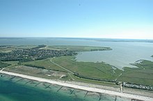
Saaler Bodden


The Saaler Bodden is a lagoon developed Bodden , of the southwestern (innermost) part darss-zingst bodden chain forms. It is located about 30 kilometers northeast of Rostock . The Fischland isthmus seals off the Saaler Bodden completely to the west from the Baltic Sea . The average depth is around two meters, which limits its use mainly to pleasure craft shipping and sport fishing.
The southern part of the Bodden, to which the town of Ribnitz-Damgarten borders, is called Ribnitzer See . In the west of the Ribnitzer See the Recknitz river flows into the Saaler Bodden. There are also the two eponymous districts of Ribnitz-Damgarten, the only town on the Saaler Bodden: Ribnitz west of the river and Damgarten east of it.
In addition to the Recknitz near Damgarten, the Klosterbach near Ribnitz and the Körkwitz Bach and the Fischergraben at Körkwitz flow into the Ribnitz Lake. At room in its lower reaches opens Ziegelgraben said Saaler stream in the bay.
In the northeast, the Koppelstrom forms the transition to the Bodstedter Bodden . Two former water arms to the Baltic Sea , the Permin and the Loop , have silted up since the 14th century.
The water of the Saaler Bodden is slightly salty (1–3 per thousand ).
A small part of the Saaler Bodden in the northeast belongs to the Western Pomerania Lagoon Area National Park .

