Rickenbach (Schwarzach)
| Rickenbach | ||
|
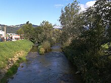
The Rickenbach in the Rickenbach district - below the Doppelmayr company |
||
| Data | ||
| Water code | AT : 81150401 | |
| location | Vorarlberg , Austria | |
| River system | Rhine | |
| Drain over | Schwarzach → Dornbirner Ach → Rhine → North Sea | |
| Source height | 920 m | |
| muzzle | in Schwarzach (Dornbirner Ach) Coordinates: 47 ° 27 '4 " N , 9 ° 44' 29" E 47 ° 27 '4 " N , 9 ° 44' 29" E |
|
| Mouth height | 410 m | |
| Height difference | 510 m
|
|
| Catchment area | 7.9 km² | |

The Rickenbach is a flowing body of water that flows from Oberbildstein (municipality of Bildstein , source at around 920 m above sea level ) over the largely natural ravine of the same name "Rickenbach" and the Vorarlberg communities of Wolfurt and Schwarzach (mouth around 410 m above sea level . ). The stream begins at river kilometer 5.46 and flows in a slight curve to the north from east-northeast to west-southwest at river kilometer 0.00 in the Schwarzach .
The Rickenbach is largely not on its course curbed and direct access usually possible, although by the topography makes it difficult ( Tobel ). In the area of the municipality of Wolfurt, the Rickenbach was largely straightened .
Surname
Ricke is an Old High German word and, according to Werner Vogt, means Felsenge or Felsschlucht . The name occurs several times in the lower Rhine valley in Vorarlberg (e.g. Ricken as a field name, Rickenloch, Rickenbachtobel, Rickenbacherholz etc.). There are also Rickenbach in Switzerland and in southern Germany. According to Leo Jutz's Vorarlberg dictionary, "Rick" has the meaning of a loop or knot, e.g. B. on a grain sheaf.
Tributaries
The catchment area of the Rickenbach amounts to a total of 7.9 km², of which around 3.9 km² are accounted for by the tributary of the Minderach . The Rickenbach itself has a catchment area of around 3.6 km².
At river kilometers 5.46, in the municipality of Bildstein , district Oberbildstein, the Rickenbach rises from a source and keeps its name from here on.
Significant tributaries of the Rickenbach are (seen from the origin) in the upper area up to the mouth at river kilometers:
- 3,805 the Mühlebach (Bildstein),
- 2.805 of the Seaga Trench (Bildstein),
- 0.89 the Minderach (Schwarzach / Wolfurt)
- 0.09 the Egelwiesgraben (Wolfurt)
as well as some other, smaller tributaries.
At river kilometer 0.00 the Rickenbach flows into the Schwarzach at the district Rickenbach near Wolfurt (river kilometer 2.15 the Schwarzach, already municipality area Schwarzach).
Offending communities
In the upper area, the Rickenbach flows for about two thirds of its length through the political municipality of Bildstein (Oberbildstein).
The brook flows into the municipality of Wolfurt at around river kilometer 1.825 and forms a border river between the municipality of Wolfurt and Bildstein up to river kilometer 1.71. At river kilometer 0.04 the Rickenbach flows out of the municipality of Wolfurt again (near the confluence of the Rickenbach into the Schwarzach).
Economic use
The Rickenbach was previously used economically. Especially the hydropower among other things z. B. for the company Doppelmayr , under whose premises the Rickenbach partly still flows, and for the bobbin thread factory Zuppinger. A mill was also mentioned in the early modern period (1536, 1571, 1680, 1795 and 1797). In 1680 and 1797 there is also talk of a saw and 1795 of a Lohrstampf. In the upper area of the Rickenbach there is the flowing Mühlebach from the municipality of Bildstein at river kilometer 3.805, which also indicates the use of the water for economic purposes.
In the Rickenbachtobel sandstones were mined, which were processed into stairs, window lintels, grave plinths, whetstones, whetstones , ovens, paving stones and building stones, etc. a. the sandstones were also delivered to the local whetstone loops in Schwarzach .
Flood
The Rickenbach is now a relatively "tamed" stream. Heavy floods from the years: 1674 (twice), 1701, 1702, 1752, 1780, 1901, 1910, 1913, 1924, 1934, on July 11, 1957 and on August 19, 1957 have been handed down.
Individual evidence
- ↑ Alfons Fischer: The Rickenbach in Wolfurt, portrait of a torrent in its environment in "Heimat Wolfurt", No. 3, Journal of the Heimatkundekreis, May 1989, p. 3. See also Johann Christoph Adelung in Grammatical-Critical Dictionary of High German Dialect, Vienna 1811, search term: Die Haferricke.
- ↑ Alfons Fischer: The Rickenbach in Wolfurt, portrait of a torrent in its environment in "Heimat Wolfurt", issue 3, magazine of the local history circle, May 1989, p. 3.
- ↑ Alfons Fischer: The Rickenbach in Wolfurt, portrait of a torrent in its environment in "Heimat Wolfurt", issue 3, magazine of the local history circle, May 1989, p. 24.
- ↑ Alfons Fischer: The Rickenbach in Wolfurt, portrait of a torrent in its environment in "Heimat Wolfurt", issue 3, magazine of the local history circle, May 1989, p. 24.
- ↑ Alfons Fischer: The Rickenbach in Wolfurt, portrait of a torrent in its environment in "Heimat Wolfurt", issue 3, magazine of the local history circle, May 1989, p. 20.
