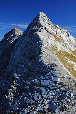
Corrugated tips
| Southern Riffelspitze | ||
|---|---|---|
|
Southern Riffelspitze, left the northern Riffelspitze |
||
| height | 2263 m | |
| location | Bavaria , Germany | |
| Mountains | Wetterstein Mountains | |
| Coordinates | 47 ° 26 '12 " N , 10 ° 59' 52" E | |
|
|
||
| rock | Wetterstein lime | |
| Age of the rock | Triad | |
The Riffelspitzen are two neighboring peaks in the Wetterstein Mountains , Bavaria . The southern Riffelspitze is 2263 m high, the northern Riffelspitze reaches 2242 m .
Location and surroundings
The Riffelspitzen rise in the Waxensteinkamm in the northern Wetterstein Mountains. In the north lies the Eibsee , in the south runs the Höllental . The neighboring mountain in the southwest, separated by the 2163 m high Riffelscharte , is the Riffeltorkopf ( 2230 m ), to the northeast the ridge continues to the 2264 m high Schönangerspitze .
While in the south schrofendurchsetzte rich grassy slopes almost to the summit ridge covered the walls to the north steep.
Bases and paths
The Riffelscharte located to the southwest forms a transition between the north and south sides of the Waxenstein ridge, it can be reached via marked hiking trails from the Eibsee (partly insured as a via ferrata ) or from Ehrwald , but also from the Höllental. The Höllentalangerhütte ( 1387 m ) is the most important base for climbing the mountains.
The southern Riffelspitze can be reached from the Riffelscharte in about 20 minutes via a climb of difficulty I (UIAA) . A climbing route of difficulty V- leads through the northwest face.
The normal route to the northern Riffelspitze leads from the southern Riffelspitze in 20 minutes with difficulty I to the summit. In addition, the mountain can be climbed via the southeast ridge (I) and the northeast ridge (II). The route through the north-west face, which Willo Welzenbach and E. Müller started for the first time, has a level of difficulty V.
literature
- Stephan Beulke: Wetterstein. A guide for valleys, huts and mountains (= Alpine Club Guide . Series: Northern Limestone Alps. ). Written according to the guidelines of the UIAA. 4th, unchanged edition. Bergverlag Rother, Munich 1996, ISBN 3-7633-1119-X , p. 147 ff.
Individual evidence
- ↑ Federal Office for Cartography and Geodesy , State Office for Surveying and Geoinformation Bavaria : Digital Topographic Map 1:50 000, BayernViewer ( Memento of the original from October 2, 2011 in the Internet Archive ) Info: The archive link was automatically inserted and not yet checked. Please check the original and archive link according to the instructions and then remove this notice. , accessed September 23, 2010

