Rindoon
|
Rindoon Rinn Dúin |
||
 Rindoon |
||
| Geographical location | ||
|
|
||
| Coordinates | 53 ° 32 '17 " N , 7 ° 59' 38" W | |
| Waters 1 | Lough Ree | |
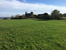
Rindoon (also Rindown , Rinndown ; Irish : Rinn Dúin , " Headland des Dúns ") is a peninsula in County Roscommon in Ireland . It lies between the places Athlone and Roscommon , about in the middle of the west side of Lough Ree at the narrow point between the northern and southern lake.

prehistory
The eponymous Dun Rinn Dúin is the only evidence of an old Irish use of the peninsula. Rinn Dúin was an inland promontory fort . The region by the lake belonged to the land of the Hy-Many clan (Uí Maine). An early Christian cross slab , two hand bells and a crucifix made of bronze , originate from here and are now in the National Museum of Ireland in Dublin . They suggest that there was untold Christian activity here. In 842 the Viking Turgesius is said to have wintered on an island in Lough Ree.
history
It is also recorded that Ruaidhrí Ua Conchobair , King of Connacht , led his boats over the ice to Rinn Dúin during the unusually harsh winter of 1156. The Anglo-Normans John de Courcy served Rindoon according to the Annals of the Four Masters in 1199 as a bridgehead . After his defeat in the fighting for Connacht, he withdrew his men from Rindoon across Lough Ree.
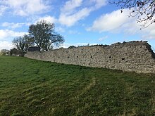
The strategic value of the peninsula was also recognized by Geoffrey de Marisco (1171-1246). He built a castle and a garrison in connection with the fighting for Connacht in 1227. Together with them, the ruins of the pier, the wall, the hospital, two churches and a windmill lie in the pasture. In 1229, Rindoon was set on fire by an O'Connor clan leader. It is unclear whether the castle burned down completely. In 1233, however, it was still unfinished. The market cross , the moat and the rampart are mentioned in 1236 when another O'Connor conquered the place, but failed because of the castle. In 1251 the enclosure of the settlement on Rindoon was restored. The wall that still exists comes from that period. In the more peaceful period that followed, the town was supplied with corn, cloth and wine from Bordeaux across the Shannon . In 1544, when Ulick Burke, 1st Marquess of Clanricarde , received the territory of St. John's of Rindoon, the castle must have been in ruins.
Rindoon is one of the finest examples of an abandoned medieval settlement in Ireland. Founded in the 13th century with the construction of the castle and the wall, one of the most valuable examples in Ireland, it was abandoned in the 14th century.
The archaeological importance of Rindoon lies in the fact that no significant structural changes have taken place on the peninsula since the 14th century. It is also certain that Rindoon or Rinnagan the place where the crucifixion commemorative plaque of bronze was sold under the name "Athlone plaque" (plaque from Athlone) is known. It is the most famous early Christian metalwork in Ireland. With the bells and the cross-slab, she indicates that the unknown early monastery on Rindoon was important. Examination of the earthen structures connected to the castle shows that the cape was fortified in pre-Norman times. However, speculation remains that Rindoon was the much sought-after Longphort of the Viking Turgesius in Lough Ree.
The Promontory Fort
A system of two inner walls, a wide moat and an outer wall extends west of the castle over the central part of the peninsula and separates the tip of the peninsula. It is unclear when this facility was built, but the name of the place indicates that its origins lie in pre-Norman times.
The castle
The castle is located on a flat hill at the northeast end of the peninsula. It consists of an oval ring wall with a rectangular extension in the southwest. You enter it through a gatehouse in the north. The keep, the oldest part of the castle, is probably identical to the so-called "stone castle", which was built in 1227. Inside there are the foundations of three houses with attached buildings. Many areas are now overgrown with ivy.
The ignition of Rindoon during the "Irish Bruce Wars" in 1315 by the younger Rory O'Connor during the storming by Edward de Bruce probably led to the conquest and destruction of the castle. In 1321, however, walls were once again destroyed on Rindoon by the clan people of the O'Reillys and the O'Naghlans. It seems that the castle was ownerless in the 14th century, because parts of the curtain wall were torn down at that time. These were rebuilt in the 16th century, but the new wall was not as wide and not as high as the one in the 13th century and does not always follow the line of its predecessor. Rindoon was one of the most important fortifications used by the Anglo-Normans and remained in royal hands throughout the 12th and 13th centuries. It is barely mentioned in the 14th century and after 1344, when it was in Irish hands, it completely disappeared from the annals by the mid-16th century.
In 1574 it is referred to as "the bare castle" (the unadorned castle). The architecture, however, indicates that parts of the complex were reinforced again in the 16th and early 17th centuries. Welsh colonists were probably responsible for this. However, there are no more sources about the castle below, so it probably ceased to serve a function in the early 17th century.
The place
The street scheme is almost linear. The streets run from the gatehouse of the wall to the castle. The remains of the wall and the foundations of four houses are on a line. They might correspond to those houses mentioned in 16th century sources. There are no more traces of the market square and the market cross.
The rampart and the bridge
The wall consists of the remains of the stone wall, the gate and three towers. The wall extends from northeast to southwest across the peninsula. The masonry consists of medium to large chunks of limestone. The wall line has a height of 1.65 m to 2.10 m. References to a bridge that spanned the moat, separating the castle and town, can be found between 1280 and 1306. The pillars of this drawbridge survived, as did the peat foundations on the town side.
The church
The dates of the Church are unknown and there are few references to them. In the oldest edition of the "OS" ( Ordnance Survey / National Mapping Authority) it is referred to as "RC Chapel" (Roman Catholic Chapel). The building consisted of the nave and the choir. The current ensemble of ruins probably dates from the 13th century. The masonry here also consists of limestone quarry. To the north of the church are the ruins of a small rectangular building that could have served as the "Penal Chapel". A chapel that served as an emergency church during the Penal Laws of the 18th century against Catholics.
The hospital and St. John's Wood
There is little evidence of the Hospital of St. John the Baptist prior to the 15th century. Until 1487 the income of the hospital was insufficient to support it. In 1596, it is described as a shingle-roofed building that had a cloister and three dilapidated buildings. Their remains are to the northwest of the wall. The fragment of the early Christian “cross-slab” was discovered here during an exploration.
The 150 acre St. John's Wood is located in the lower part of Rindoon and is considered the largest natural forest area in the island's interior. The woody trees consist of yew ( Taxus baccata ), oak ( Quercus robur ), ash ( Fraxinus excelsior ), hazel ( Corylus avellana ), Irish whitebeam ( Sorbus hibernica ), bird cherry ( Prunus avium ), holly ( Ilex aquifolium ) and elm ( Ulmus glabra ). The occurrence of two species of the parasitic rootwort ( Lathraea ) and the "orchid of the year 2002", the bird's nest root ( Neottia nidus-avis ), indicate a forest tradition that has been extended over centuries.
The mill
The mill is mentioned in 1273 and 1276. Pictures from 1636 show a windmill on the cape. This coincides with the remains of that windmill that stood on a round earth wall. The cylindrical stone tower from the 17th century consists of three floors. It remained in its original size. The earth wall of this tower could have been part of the older mill.
The investor
A number of documents as well as installations on the shore and in the lake indicate the existence of a jetty off Rindoon. A ferry connecting County Roscommon from Rindoon to County Westmeath on the other side of the lake is mentioned in the early 14th century.


