Río Grijalva
| Río Grijalva | ||
|
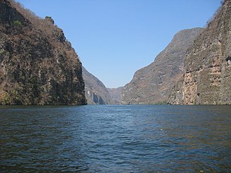
The Río Grijalva in the Cañón del Sumidero |
||
| Data | ||
| location | Guatemala , Mexico | |
| River system | Río Grijalva | |
| source | in the Sierra de los Cuchumatanes ( Guatemala ) | |
| Source height | 4026 m | |
| muzzle |
Campeche Bay ( Gulf of Mexico ) Coordinates: 18 ° 35 ′ 20 ″ N , 92 ° 41 ′ 20 ″ W 18 ° 35 ′ 20 ″ N , 92 ° 41 ′ 20 ″ W |
|
| Mouth height | 0 m | |
| Height difference | 4026 m | |
| Bottom slope | 8.4 ‰ | |
| length | 480 km | |
| Catchment area | 134,400 km² | |
| Reservoirs flowed through | La Angostura , Manuel M. Torres Dam , Nezahualcóyotl (reservoir) | |
| Big cities | Villahermosa | |
|
The Río Grijalva in Villahermosa |
||
The Río Grijalva is a 766 km long river in southeastern Mexico . It was named after its Spanish explorer Juan de Grijalva .
geography
A few kilometers from its headwaters not far from the Mexican border in the Sierra de los Cuchumatanes in Guatemala , the Río Grijalva first flows northwest, then turns north and flows through the Mexican states of Chiapas and Tabasco . To the north-east of Villahermosa it connects with the western of the three mouths of the Río Usumacinta and forms the swampy river delta of the Pantanos de Centla ; about 25 kilometers further north it flows into the Gulf of Mexico .
Cities
Important cities on or in the vicinity of Río Grijalva are Tuxtla Gutiérrez , Cardénas and Villahermosa. North of Tuxtla Gutierrez, it flows through the Cañón del Sumidero .
economy
In the course of its current are the largest hydropower plants in Mexico: La Angostura (Dr. Belisario Domínguez), Malpaso (Netzhualcoyotl), Manuel M. Torres Dam (Chicoasén) and Peñitas (General Angel Albino Corzo). The power plants along the river provide around 30% of the electricity produced in Mexico. The Cañón del Sumidero , cut deep into the mountains, is of great importance for tourism in the region.
history
Since the Río Grijalva often overflowed its banks in earlier times, neither ancient nor new cities can be found directly on its banks. The pre-Columbian ruins of Chiapa de Corzo are about 100 m above the river level. In 1518 the estuary of the river was discovered and crossed by a Spanish expedition corps under the leadership of Juan de Grijalva. In October / November 2007 - despite the reservoirs used to regulate the water - several villages along the river were flooded and partially destroyed; hundreds of people were killed.
fauna
Unlike the Río Usumacinta, the Río Grijalva is interrupted by several reservoirs, which has had a negative impact on biodiversity; Former habitats of jaguars, crocodiles, river turtles etc. were largely destroyed. Only the marshy biosphere reserve of the Pantanos de Centla at the mouth of the river still offers largely natural habitats, especially for birds.

