Ripley (New York)
| Ripley | ||
|---|---|---|
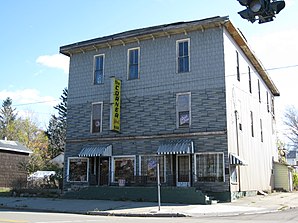
 Corner Bar in Ripley |
||
| Location in New York | ||
|
|
||
| Basic data | ||
| Foundation : | March 1, 1817 | |
| State : | United States | |
| State : | new York | |
| County : | Chautauqua County | |
| Coordinates : | 42 ° 14 ′ N , 79 ° 42 ′ W | |
| Time zone : | Atlantic Standard Time ( UTC − 4 ) | |
| Residents : | 2,415 (as of 2010) | |
| Population density : | 19.1 inhabitants per km 2 | |
| Area : | 126.6 km 2 (about 49 mi 2 ) of which 126.3 km 2 (about 49 mi 2 ) are land |
|
| Height : | 395 m | |
| Postal code : | 14775 | |
| Area code : | +1 716 | |
| FIPS : | 36-61885 | |
| GNIS ID : | 0979424 | |
| Website : | www.Ripley-NY.com | |
Ripley is a town on the south bank of Lake Erie in Chautauqua County , in the westernmost tip of the US state New York . In a 2010 census, the population was 2,415. The city was named after General Eleazer Wheelock Ripley while he was still alive .
geography
The city has a total area of 126.6 km² (as of 2010). The roads Interstate 90 , US 20 , NY 5 and NY 76 pass Ripley.
history
The first settlements in Ripley existed from 1804, at the same time as neighboring Portland . In 1813 Portland was raised to a city with the inclusion of Ripley, in 1817 Ripley was then separated from Portland and founded as an independent city.
population
In 2010 there were 2,415 people in 1,259 households in Ripley. The population density is 19.1 people per km².
Born in Ripley
- Richard Ely (1854–1943), economist
- Benjamin Franklin Goodrich (1841–1888), founder of BF Goodrich
- John Testrake (1927-1996), pilot and captain of TWA Flight 847
Web links
Commons : Ripley, New York - Collection of images, videos, and audio files
