Suir
| River Suir - An tSiúr | ||
|
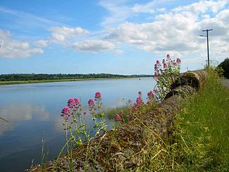
The River Suir near Waterford |
||
| Data | ||
| location | Republic of Ireland | |
| River system | Suir | |
| River basin district | South Eastern RBD | |
| source | north of Templemore in County Tipperary | |
| muzzle | at Dunmore East in the Celtic Sea Coordinates: 52 ° 8 '20 " N , 6 ° 57' 37" W 52 ° 8 '20 " N , 6 ° 57' 37" W.
|
|
| length | 183 km | |
| Left tributaries | River Barrow | |
The Suir [ ʃuːr ] ( Irish : An tSiúr or Abhainn na Siúire , English River Suir ) is a river in the south of Ireland with a total length of 183 km.
Its source is north of the town of Templemore in County Tipperary . From there, it flows through the towns of Loughmore , Thurles and Holycross , joins the Aherlow and Tar Rivers, and flows eastward in front of the Comeragh Mountains . The river forms at this point the border between County Waterford and County Kilkenny and flows through the towns Cahir , Clonmel and Carrick-on-Suir before the city Waterford reached. In the north of the city, the Suir joins the River Barrow - shortly after it has absorbed the River Nore - into a single stream that flows into the Celtic Sea a few kilometers south of Waterford at Dunmore East . The three rivers are called the Three Sisters in parlance . At the mouth of the Hook Head peninsula stands the lighthouse of the same name , which was built in 1172, making it the oldest in Europe.
Historically, the river is important for the settlement of the interior by the Vikings in the early Middle Ages . They founded settlements along the coast and rivers from the middle of the 9th century.
The Suir is very popular with anglers who fish for salmon and brown trout here.
