River Wyre (Morecambe Bay)
| Wyre | ||
|
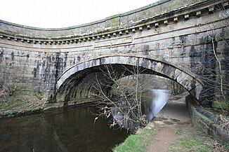
The aqueduct of the Lancaster Canal over the Wyre. |
||
| Data | ||
| location | Lancashire , England | |
| River system | River Wyre | |
| River basin district | North West | |
| confluence | by Tarnbrook Wyre and Marshaw Wyre 53 ° 58 ′ 53 ″ N , 2 ° 39 ′ 59 ″ W |
|
| muzzle | between Fleetwood and Knott End-on-Sea Coordinates: 53 ° 55 ′ 43 " N , 3 ° 0 ′ 17" W 53 ° 55 ′ 43 " N , 3 ° 0 ′ 17" W
|
|
| length | 45 km | |
| Left tributaries | River Calder , River Brock | |
| Communities | Abbeystead , Fleetwood | |
The River Wyre is a river in Lancashire , England . It arises from the confluence of the Tarnbrook Wyre and Marshaw Wyre in Abbeystead in the Forest of Bowland .
In Abbeystead, the River Wyre flows through the Abbeystead Reservoir, built in 1855, which is no longer used today, but is still clearly visible. The reservoir was once supposed to secure the water level of the Wyre so that the spinning and weaving mills further down the river could continue to operate. Since 1980 there has been a tunnel connection through which water can be pumped from the River Lune from Caton to Abbeystead in order to secure the water supply in southern Lancashire with the help of the River Wyre.
The River Wyre initially flows in a westerly direction until it describes an arc to the south at Dolphinholme . South of Forton, the Wyre crosses the M6 motorway and then flows east past Garstang , to the south of which it crosses under the Lancaster Canal .
Between St Michael's on Wyre and Thornton , the Wyre flows west and then north to flow into Morecambe Bay between Fleetwood and Knott End-on-Sea .
