Rivière Eastmain
| Rivière Eastmain | ||
|
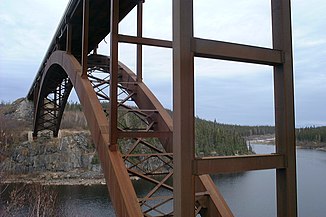
Bridge over the Rivière Eastmain |
||
| Data | ||
| location | Jamésie , North du Québec in Québec (Canada) | |
| River system | Rivière Eastmain | |
| origin |
Lac Bréhat 52 ° 31 ′ 30 ″ N , 70 ° 52 ′ 0 ″ W. |
|
| muzzle | in the James Bay coordinates: 52 ° 14 ′ 30 " N , 78 ° 34 ′ 0" W 52 ° 14 ′ 30 " N , 78 ° 34 ′ 0" W. |
|
| Mouth height |
0 m
|
|
| length | 756 km | |
| Catchment area | 46,400 km² | |
| Right tributaries | Rivière Opinaca , Rivière à l'Eau Claire | |
| Reservoirs flowed through |
Reservoir de l'Eastmain 1 , Opinaca Reservoir |
|
| Communities | Eastmain | |
| Most of the water is diverted to the Robert-Bourassa Réservoir | ||
|
Eastmain - original catchment area in yellow and orange, the derived catchment area in orange |
||
|
Eastmain in December 2005 on Route de la Baie James |
||
The Rivière Eastmain is a tributary of James Bay in the west of the Canadian province of Québec .
It has its origin in north-central Québec, flows 756 km in a westerly direction and flows into James Bay . It drains an area of 46,400 km².
East Main is an old name for the eastern side of James Bay. The Cree settlement of Eastmain lies at the estuary.
Since the late 1980s, much of the Eastmain's water has been diverted north to the Opinaca Reservoir (950 km² of water). From there it enters the Robert-Bourassa Réservoir of the La Grande complex of Hydro-Québec . Only a fraction of the former volume of water flows through the lower reaches of the Eastmain, so that it can freeze in winter (see photograph). The mean discharge of the river before its diversion was 930 m³ / s at the mouth. This reaches a width of 2.5 km, the estuary extends up to 27 km inland.
Another hydroelectric project on the upper reaches of the Eastmain was completed in 2012. It was part of the original 1975 hydropower project. The Réservoir de l'Eastmain 1 has a water surface of 603 km². It supplies the Eastmain-1 and Eastmain-1-A hydropower plants with an output of 507 and 768 MW respectively.
The Eastmain was named after the main east district of the Hudson's Bay Company , which stretched east and south of Hudson Bay . One of the oldest fur trading posts was built on the Eastmain in 1685. A bridge crosses the Rivière Eastmain along the Route de la Baie James .
Discharge measurements
- Rivière Eastmain at the gauge above the Gorge de Basile - hydrographic data from R-ArcticNET
- Rivière Eastmain at the gauge above Rivière Cauouatstacau - hydrographic data from R-ArcticNET
- Rivière Eastmain at the gauge above the Prosper Gorge - hydrographic data from R-ArcticNET
- Rivière Eastmain at the gauge above the Gorge de Basile - hydrographic data from R-ArcticNET


