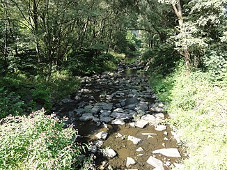
Ropičanka
| Ropičanka | ||
|
Ropičanka |
||
| Data | ||
| location | Moravskoslezský kraj , Czech Republic | |
| River system | Or | |
| Drain over | Olsa → Or → Stettiner Haff | |
| source | Northern slope of the Ropice in the Moravian-Silesian Beskids 49 ° 36 ′ 2 ″ N , 18 ° 35 ′ 22 ″ E |
|
| Source height | 840 m nm | |
| muzzle | on the southern outskirts of Český Těšín in the Olsa coordinates: 49 ° 43 ′ 42 ″ N , 18 ° 37 ′ 35 ″ E 49 ° 43 ′ 42 ″ N , 18 ° 37 ′ 35 ″ E |
|
| Mouth height | 270 m nm | |
| Height difference | 570 m | |
| Bottom slope | 37 ‰ | |
| length | 15.4 km | |
| Catchment area | 36.29 km² | |
| Drain |
MQ |
600 l / s |
| Residents in the catchment area | 3513 | |
The Ropičanka ( Polish Ropiczanka ), called Řeka on the upper reaches , is a left tributary of the Olsa in the Czech Republic .
course
The Ropičanka rises on the northern slope of the Ropice (1082 m) in the Moravian-Silesian Beskids . Your course leads north through a deeply cut mountain valley in which the village of Řeka extends. Between the Godula (737 m) and Gutský vršek (741 m) the Ropičanka flows into the Beskid foothills near Kopanice. The villages of Pržno, Smilovice and Rakovec are located on its further course . Above Střítež , a water canal leads from the Ropičanka to the Černý potok. It is used to supply water to the Těrlicko reservoir on the Stonávka and has a discharge rate of 0.041 m³ / s.
From Střítež the river turns to the northeast, its course is followed by the railway line Český Těšín - Frýdek-Místek . Via Ropice and Rakovec the Ropičanka finally reaches Český Těšín, where it flows into the Olsa on the southern outskirts on the Polish border between Svibice and Błogocice .
Tributaries
- Javorová (r), at the foot of the Šindelná (1000 m)
- Příslopský potok (l), Řeka
- Hlavičský potok (r), Řeka
- Juryský potok (l), Řeka
- Godula (l), Řeka
- Vělopolka (l), Ropice
Web links
