Godula (mountain)
| Godula | ||
|---|---|---|
|
View to the Godula |
||
| height | 737 m nm | |
| location | Czech Republic | |
| Mountains | Moravian-Silesian Beskids | |
| Coordinates | 49 ° 38 '58 " N , 18 ° 33' 1" E | |
|
|
||
The Godula is a 737 m high mountain in the northeast of the Moravian-Silesian Beskids .
location
The mountain rises 15 kilometers east of the town of Frýdek-Místek . To the north it falls into the Beskid foothills. To the west lies the Ráztoka valley, to the east the deeply cut valley of the Ropičanka runs . Towards the south, there is a ridge that extends over the Ropička (918 m), the Příslop (945 m) to the Velký Lipový (999 m).
Neighboring places are Godula in the west, Komorní Lhotka and Smilovice in the north, Guty in the east and Řeka in the southeast. The Salasche Perlík is located on the Godula Saddle.
history
The Beskid foothills were settled at the foot of the mountain in the middle of the 15th century. Two hundred years later, the Pasekaren settled in the mountain valleys and later also in the mountains. In 1644 the Pasekarendorf Řeka was founded.
During the time of state Catholicism, the Godula served as a secret meeting place for Protestant Christians from the surrounding villages. In 1782 they built their own tolerance church in Cameral Elgoth .
In 1931 a memorial stone was erected on the Godula ridge on the occasion of the 150th anniversary of the Edict of Tolerance .
geology
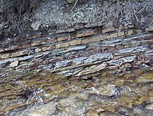
The Godulaberg, consisting of a fine-grain sandstone , offers good opportunities to study the layer structure of the sandstone sedimentation thanks to its natural outcrops that are accessible in some quarries.
In the 19th century, a sandstone quarry opened at the western foot of the mountain in the Ráztoka valley. Another important quarry is located on the eastern flank in the Řeka valley . Around 1901, three mining sites were active on the mountain. Two belonged to the Archducal Cameral Directorate Teschen and one of the first Silesian-Galician stone union Maximilian H. Krasny in Mährisch Ostrau . Because of its excellent technical and physical values, the stone has been used for all types of buildings and as path material. In particular, these were architectural parts, stairs, paving, floor slabs, bridge structures, hydraulic engineering (bank reinforcements) and wall blocks.
Modern trade names are Řeka sandstone , Teschener sandstone or in Czech Těšínský pískovec . The mineable layers are between 0.3 and 6 meters thick.
The facades of buildings in Ostrava, Cieszyn / Český Těšín, Hranice na Moravě , Krakow , Warsaw, as well as churches in Třinec (Trzynietz), Karviná and Dombrau, and also industrial buildings are made from this sandstone in Vítkovice (Witkowitz), Třinec (Trzynietz) and Frýdek-Místek (Friedek-Mistek). The theater in Zlín , the new train station in Cheb and the buildings of the former Vojenská technická akademie Brno ( Brno Military Technical Academy) deserve special mention .

The series of rocks formed in the late Cretaceous period , characterized by their greenish, gray and reddish color nuances and their occurrence mainly extending to the Beskids , were named after this mountain as Godula layers . These layers represent a flysch complex of gray-green sandstones, gray-green clay slates and sandy claystones with a layer structure. These slates and claystones alternate with sandstones. The sandstone deposits consist of banks of mostly fine-grained sediments, which have a play of colors between gray-green, blue-gray and blue-green. Sometimes they are also medium-grain, coarse-grained to conglomerate . The sandstone is pebbly bound and contains glauconite . This is what gives it its strength and color.
Originally Godula sandstone was just the name of the stone quarried on Godula Mountain, which is of great importance for the architecture of the near and far region. Early geological research took up this name and applied it as a lithological technical term to all sandstone deposits of the same age and form in the Beskids and the neighboring Carpathians. Regarding its age, it lies in the Cretaceous area from Cenoman to Turon . The age of the entire Godula strata extends from the Cenoman to the Santon .
The Godula layers have been extensively studied on both the Polish and the Czech side. The first comprehensive scientific investigation of all Carpathian sandstone deposits , including the Godula sandstones , was carried out by Ludwig Hohenegger (director of the Berg und Hüttenkammer Teschens) around 1860. Hohenegger is considered a pioneer in researching the Carpathian flysch.
The thickness of the Godula layers on the Polish side (Burtan, Konior, Książkiewicz, 1937) was determined to be 2,000 meters and on the Czech side (Menčik, Pesl, 1955) 2,450 meters.
Individual evidence
- ^ Ivo Chlupáč, Rostislav Brzobohatý, Jiří Kovanda, Zdeněk Stráník: Geologická minulost Ceské Republiky . Praha (Academia) 2002, pp. 289, 293 ISBN 80-200-0914-0
- ^ L. Hohenegger: Geognostic map of the Northern Carpathians in Silesia and the adjacent parts of Moravia and Galicia . Gotha (Justus Perthes) 1861


