
Rotkopf (Allgäu Alps)
| Redhead | ||
|---|---|---|
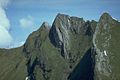
 Rotkopf from the east between Schneck (left, with its east wall) and the Laufbacherecksattel (far right at the edge of the picture) |
||
| height | 2194 m above sea level NHN | |
| location | Bavaria , Germany | |
| Mountains | Thumb group , Allgäu Alps | |
| Dominance | 0.5 km → Schneck | |
| Notch height | 83 m ↓ Gemswännele | |
| Coordinates | 47 ° 23 '27 " N , 10 ° 22' 51" E | |
|
||
| First ascent | by locals | |

As a redhead is called three inconspicuous summit ridge between Schneck the south and the run Eck to the north. The three peaks are 2188 m (north peak), 2194 m (central peak) and 2183.4 m (south peak) high.
Ascent
There is no marked path leading to the Rotkopf. It can be reached from the Laufbacher Eck saddle, but requires absolute surefootedness and a head for heights. The transition from the central summit to the south summit takes place over a narrow, rugged rock ridge that can only be climbed in the Reitsitz.
botany
The botany of the Rotkopf is as diverse as that of Höfats or Schneck.
literature
- Thaddäus Steiner : Allgäuer Bergnames , Lindenberg, Kunstverlag Josef Fink, 2007, ISBN 978-3-89870-389-5
- Thaddäus Steiner: The field names of the municipality of Oberstdorf im Allgäu , Munich, self-published by the Association for Field Name Research in Bavaria, 1972
- Zettler / Groth: Alpine Club Guide Allgäu Alps . Munich, Bergverlag Rudolf Rother 1984. ISBN 3-7633-1111-4
Web links
photos
Rotkopf vom Himmelhorn (from left: north summit, middle summit, south summit). On the far left the Laufbacher Eck saddle
