
Ruaux
| Ruaux | ||
|---|---|---|
|
||
| local community | Plombières-les-Bains | |
| region | Grand Est | |
| Department | Vosges | |
| Arrondissement | Epinal | |
| Coordinates | 47 ° 58 ' N , 6 ° 25' E | |
| Post Code | 88370 | |
| Incorporation | 1st January 1973 | |
 Saint-Jean-Baptiste church |
||

Ruaux is a former French commune with the last counted 698 inhabitants (as of 1968) in the Vosges department in the Grand Est region (until 2015 Lorraine ). Ruaux has been part of the spa town of Plombières-les-Bains since January 1, 1973 (until 1991 in the legal form of a Commune associée ).
location
Ruaux is located about 30 kilometers south of Épinal and ten kilometers southwest of Remiremont in the mountain landscape of the Vôge in the southwest of the Ballons des Vosges Regional Nature Park . The plateau on which Ruaux lies (approx. 520 m above sea level) rises 120 m above the Augronne valley , which is filled by the town of Plombières-les-Bains. Four kilometers west of Ruaux, the upper reaches fer Sémouse marks the border with the municipality of Le Clerjus ; Immediately south of the village of Ruaux, the border with the Haute-Saône and Bourgogne-Franche-Comté regions runs .
history
Earlier spellings of the place name were: Rual (1417), Ruaulx (1590), Ruault (1593), Ruyal, Ruyat and Ruya (16th century), Ruaux (1656), Ruault (1663), Ruoz (1678), Ruaux or Ruhaut (1704) and Rouaux (1711). There was also the name Ruaux-les-Plombières.
The village of Ruaux belonged to the county of Burgundy and from 1704 onwards to the Duchy of Lorraine. Later, by edict in 1751, the village was assigned to the Bailiwick of Remiremont. The church, dedicated to St. John the Baptist, was part of the parish in Aillevillers in the Faverney deanery of the diocese of Besançon .
| 1821 | 1841 | 1866 | 1886 | 1906 | 1926 | 1946 | 1954 | 1962 | 1968 |
|---|---|---|---|---|---|---|---|---|---|
| 1,056 | 1,163 | 1,270 | 1,063 | 950 | 764 | 688 | 722 | 702 | 698 |
Attractions
- Saint-Jean-Baptiste church, in its current form a reconstruction from the years 1781/1782
- Notre-Dame de Consolation chapel, built in 1899 when an old cemetery was moved
- Water tower
- Château des Fées ( Castle of the Fairies ) on a wooded mountain spur west of Ruaux with ruins from the 11th and 12th centuries and remains of polygonal walls from the 15th century

Notre-Dame de Consolation chapel
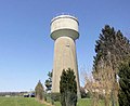
Water tower

Ruins of the Château des Fées


._2016-03-21.JPG)
supporting documents
- ^ Paul Marichal: Dictionnaire topographique du département des Vosges, Paris, Impr. Nationale, 1941
- ↑ Le département des Vosges: Statistique historique et administrative, Nancy, 1847
- ↑ Ruaux on cassini.ehess.fr
- ^ Entry in the Base Mérimée of the Ministry of Culture. Retrieved March 3, 2018 (French).
- ^ Entry in the Base Mérimée of the Ministry of Culture. Retrieved March 3, 2018 (French).
- ↑ Château des Fées on enlorraine.unblog.fr (French)