Rupertshofen
|
Rupertshofen
community Attenweiler
|
|
|---|---|
| Coordinates: 48 ° 9 ′ 3 ″ N , 9 ° 40 ′ 5 ″ E | |
| Height : | 585 m above sea level NHN |
| Incorporation : | 1st January 1975 |
| Postal code : | 88448 |
| Area code : | 07357 |
|
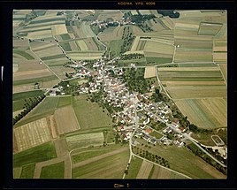
Rupertshofen (Photo at the Baden-Württemberg State Archives )
|
|
Rupertshofen is a district of the community Attenweiler in the district of Biberach in Baden-Württemberg . The village on a flat slope to the Mühlhauser Bach is about two kilometers northwest of Attenweiler.
Today's community Attenweiler was formed on January 1, 1975 by the union of the communities Attenweiler, Oggelsbeuren and Rupertshofen.
history
According to Alemannic grave finds, there was a settlement from the Merovingian period here . Rupertshofen belonged to the Bailiwick of Oggelsbeuren and like it was under the rule of Warthausen since the 14th century . After 1446 the place was fiefdom of von Stein and von Rechberg . 1695 came Rupert Hofen to the pin Buchau , which is also the majority of the manorial held.
As a result of the secularization of the monastery in 1803, Oggelsbeuren came to the princes of Thurn and Taxis . The state sovereignty fell in 1806 to the Kingdom of Württemberg , which subordinated the place to the Oberamt Ehingen in 1810 . A separate mayor's shop was established in 1811.
The Vogelhof homestead belongs to Rupertshofen.
Attractions
- Catholic parish church of Saint Vitus, built in 1810
Web links
- Rupertshofen at LEO-BW
- Attenweiler community (with photos)
Individual evidence
- ^ Federal Statistical Office (ed.): Historical municipality directory for the Federal Republic of Germany. Name, border and key number changes in municipalities, counties and administrative districts from May 27, 1970 to December 31, 1982 . W. Kohlhammer, Stuttgart / Mainz 1983, ISBN 3-17-003263-1 , p. 545 .


