Röhlingen
|
Röhlingen
City of Ellwangen
|
|
|---|---|
| Coordinates: 48 ° 56 ′ 40 ″ N , 10 ° 13 ′ 5 ″ E | |
| Height : | 459 m |
| Area : | 43.37 km² |
| Residents : | 3738 (Dec. 31, 2013) |
| Population density : | 86 inhabitants / km² |
| Incorporation : | January 1, 1972 |
| Postal code : | 73479 |
| Area code : | 07965 |
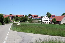
The village of Röhlingen (Swabian "Realig") in the Ostalbkreis in Baden-Württemberg is a district of Ellwangen (Jagst) . It is located about 7.4 kilometers southeast of the city center on the Sechta brook .
geography
Röhlingen is 459 m above sea level. NN in the northeastern foreland of the Swabian Alb . The district area is 4,337 hectares. The following districts and farms also belong to Röhlingen: Dettenroden , Elberschwend, Erpfental, Haisterhofen, Killingen, Neunheim, Neunstadt, Rötlen, Steigberg and Süßhof.
history
First settlements
People settled early on on the fertile soils in the Black Jura . Archaeological finds in the Horn Breite corridor suggest that the Röhlingen area was already inhabited in the Middle and Neolithic. Numerous burial mounds from the Bronze Age and especially the Hallstatt Age were found, including in Röhlingen, Haisterhofen and Killingen.
During the construction of the Upper German-Raetian Limes in the 1st and 2nd centuries AD, the boundary was cut over a length of 8 km in a north-easterly direction by the border fortifications. The Limes ran under today's main road. A fort is suspected, but has not been proven. Further Roman facilities or manors were located near Haisterhofen and Killingen.
Village foundation
Röhlingen was founded as an Alemannic village in the 6th or 7th century . The village name is traced back to a man named Rehilo or Rohilo who settled there with his clan. On the slope above the farm there was a cemetery that was discovered in 1990. It is assumed that there was also an early church there, but it has not been proven.
The place was first mentioned around 850 in the Vita Hariolfi about the founder of the monastery, Hariolf . According to these notes by the monk Ermenrich , Abbot Hariolf received the noble Grimold on his farm in Röhlingen ( in vico Rohilingen ) soon after the foundation of the Ellwangen monastery in 764 .
middle Ages
From around the 10th century onwards, numerous castle stalls were created in the region , including in Röhlingen, near Erpfental, in Neunstadt, Haisterhofen, Killingen, on the Gumpenweiher and in Rötlen. They were manned by forest officials from Ellwangen Abbey, who were supposed to secure the border area between Alemannia and Franconia. Some of these castle stalls were later expanded into small stone castles. In Rötlen, such a castle formed the basis for the later palace.
As ministerials of Ellwangen Abbey, the Lords of Röhlingen lived in a castle stable on the left bank of the Sechta, which was built in the 11th or 12th century. The tower hill castle was connected to a farm yard. Later the tithe barn was built there. The Burgstall is no longer visible today. The local noble family von Rohelingen was first mentioned in 1255, the last name bearers in the 15th century.
Local nobility existed in Killingen and Haisterhofen until the late Middle Ages. From the 14th century, the impoverished aristocrats had to sell goods and rights. For example, Ellwangen acquired properties and rights in Röhlingen, Killingen, Neunstadt, Erpfental and Rötlen Castle.
The parish church of Röhlingen was incorporated into the Ellwangen monastery by the Bishop of Augsburg in 1328 .
Modern times
When the Ellwangen monastery was converted into a canons' monastery in 1460, the Röhlingen mark came into the possession of the prince provost of Ellwangen . In 1525, 94 Röhlinger farmers took part in the Ellwang bunch of citizens and farmers during the Peasants' War , who plundered and set fire to Ellwangen, but was defeated by the Swabian Federation .
Swedish horsemen under Claus Dietrich von Sperreuth plundered the village of Röhlingen in the Thirty Years' War on February 11, 1632. In May 1632, Sperreuter took the village of Rötlen and attacked Ellwangen from there.
The Röhlingen mark came to Württemberg in 1802 . It initially belonged to the Oberamt Rötlen and then became a municipality in the Oberamt Ellwangen , which became part of the Jagstkreis from 1818 . The municipality of Röhlingen belonged to the Ellwangen District Office until it was dissolved in 1938.
Between 1840 and 1865, numerous residents of the village emigrated to America.
In the description of the Oberamt Ellwangen from 1886 it said about the economic branches of Röhlingen: “The main means of income are agriculture and livestock; rye, spelled, barley and Haber are particularly grown; and far beyond our own needs, meadow cultivation is also extensive, fruit growing is not significant. There are two brickworks, five grinding mills, a plaster mill, two sawmills and two important beer breweries. ”The mail car connection from Ellwangen to Tannhausen led through Röhlingen. The community had a surgeon and an organized fire department.
20th century
The beginning of the 20th century also brought an expansion of the infrastructure for Röhlingen and its suburbs. In 1916 and 1917, water pipes were built in Röhlingen and four other suburbs. In 1919 a telegraph helpline was set up as a public telephone station in Rötlen . In 1922 and 1923 Elberschwend, Rötlen, Erpfental, Haisterhofen, Killingen, Steigberg and the Süßhof were connected to the new high-voltage line from Ellwangen to Tannhausen. The Röhlinger Sechta was regulated in the area of the Schlierbach confluence in 1925, and the first bridge was built over the Sechta. In 1937 Röhlingen got electric street lighting.
The new community Röhlingen was established on April 1, 1935. The previous sub-community administrations were repealed.
In April 1945 hundreds of concentration camp prisoners were driven through Röhlingen on the Hessental death march . Then 26 dead were found in the Neunheim quarry, more on the Röhlingen - Zöbingen road, on the Röhlingen local road and on the Röhlingen / Elberschendung border. A cross on the Röhlinger Friedhof marks the place where concentration camp prisoners were buried.
SS units arrived in Röhlingen on February 24, 1945. The Waffen SS blew up five bridges in the community, which resulted in significant damage to buildings. The place was increasingly attacked by low-flying aircraft. American troops marched in in April. They first destroyed the camp of the Reich Labor Service that was set up in 1934 .
In the post-war years up to 1948, the community took in many refugees and displaced persons from the former German eastern regions. Their billeting brought some problems. Heavy construction activity began in the 1950s after the municipality provided building land for the Laubbach settlement .
On January 1, 1972, the previously independent community of Röhlingen was incorporated into the large district town of Ellwangen (Jagst). It was one of the largest communities in the Aalen district .
Population development
| Röhlingen | Community / locality | |
|---|---|---|
| 1803 | 281 | |
| 1812 | 1450 | |
| 1824 | 482 | |
| 1880 | 642 | 1827 |
| 1950 | 865 | 2200 |
| 1961 | 2324 | |
| 1970 | 1115 | 2862 |
| 1980 | 1249 | 3020 |
| 1985 | 1213 | 3172 |
| 1989 | 1377 | 3281 |
| 1994 | 1481 | 3444 |
| 2010 | 1689 | 3763 |
| 2019 | 1730 | 3741 |
politics
Local council
The local council has 12 members. The distribution of seats since May 2019: BürgerListe Röhlingen (BLR) six seats, CDU five seats, Bündnis 90 die Grünen 1 seat. In addition, two CDU representatives belong to the local advisory board as advisory members.
The mayor is Walter Schlotter (BLR).
coat of arms
The coat of arms of the former municipality of Röhlingen goes back to the local nobility. It shows "two diagonally crossed silver stag sticks in red." The gentlemen of Röhlingen were related to the gentlemen of Killingen, who had silver deer antlers in their coat of arms. The red background indicates the Ellwangen Abbey.
Culture and sights

Buildings
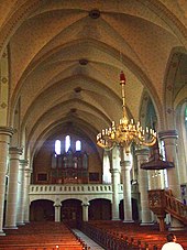
The parish church of St. Peter and Paul can be seen from afar. The originally Romanesque building was replaced by a new building built in the neo-Gothic style between 1898 and 1901 according to plans by Ulrich Pohlhammer . The Stations of the Cross frieze by Alois Schenk , created between 1919 and 1922, is considered the earliest evidence of Expressionism in a church in the Rottenburg-Stuttgart diocese .
The Guardian Angel Chapel in Neunheim was built around 1724, presumably based on a plan by the Jesuit father Jakob Amrhein , who also planned the Protestant town church in Ellwangen . The cross-shaped central building is decorated with pilasters and Corinthian capitals . The ceiling fresco of the Annunciation was created around 1730 , and the chapel was renovated in 2001.
The Katharinenkapelle in Rötlen stands on the still clearly visible castle stables .
Sports clubs
There are more than 20 clubs in Röhlingen. The wrestling club AC Röhlingen is known nationwide. The show jumper Hans-Peter Konle runs a training stable in Röhlingen. The TTC Neunstadt is also represented with a women's team in the regional table tennis league and a girls' U18 team in the table tennis association class.
Economy and Infrastructure
traffic
Röhlingen has had a direct connection to the A 7 motorway since 1987 .
The public transport bus lines can be used at the tariffs of the OstalbMobil transport cooperation as well as at the tariffs of the respective transport company.
Ellwangen airfield is located north of the Erpfental district. This is a special landing area with a 875 meter long grass runway (direction 12/30) for gliders, motor gliders, microlights and powered aircraft up to a take-off weight of 2,000 kilograms.
Long-distance cycle routes
The German Limes Cycle Route runs through the village . It follows the Upper German-Raetian Limes over 818 km from Bad Hönningen on the Rhine to Regensburg on the Danube .
education
Röhlingen has a primary school, the Johann Sebastian von Drey School. The school building from 1959 was expanded in 1982. The Catholic parish is responsible for the St. Peter and Paul Kindergarten. There is a municipal kindergarten in the Neunheim district.
Personalities
Honorary citizen
- Karl Färber (1888–1979), editor and publicist
Sons and daughters of the church
- Paul Speratus (1484–1551), Protestant reformer and song poet
- Johann Georg Allgeyer the Elder Ä. (around 1670 – after 1724), organ builder (place of birth disputed, presumably Hofen too )
- Johann Sebastian von Drey (1777-1853), Catholic theologian
Individual evidence
- ^ Ostalb between Remstal, Brenz and Ries , Stuttgart / Aalen 1973, ISBN 3-8062-0118-8
- ↑ a b c d Römisch-Germanisches Zentralmuseum Mainz (Ed.): Guide to prehistoric and early historical monuments. Volume 22: Aalen - Lauchheim - Ellwangen , Mainz 1973
- ↑ a b c d e f g h i j Liederkranz Röhlingen e. V. (Ed.): 150 years Liederkranz Röhlingen 1846-1996 , Ellwangen 1996, pages 41-70
- ↑ a b c Internet presence of the city of Ellwangen ( memento of April 13, 2013 in the Internet Archive ), accessed on June 22, 2010
- ^ Federal Statistical Office (ed.): Historical municipality directory for the Federal Republic of Germany. Name, border and key number changes in municipalities, counties and administrative districts from May 27, 1970 to December 31, 1982 . W. Kohlhammer, Stuttgart / Mainz 1983, ISBN 3-17-003263-1 , p. 445 .
- ^ Website of the city of Ellwangen - Röhlingen local council
- ↑ Internet presence of the Fliegergruppe Ellwangen e. V. , accessed June 28, 2010


