Russellville, Arkansas
|
|
This article was on the basis of substantive defects quality assurance side of the project USA entered. Help bring the quality of this article to an acceptable level and take part in the discussion ! A closer description on the resolving issues is missing. |
| Russellville | |
|---|---|
|
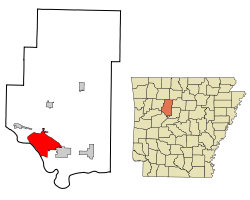
Location in county and Arkansas
|
|
| Basic data | |
| Foundation : | 1870 |
| State : | United States |
| State : | Arkansas |
| County : | Pope County |
| Coordinates : | 35 ° 17 ′ N , 93 ° 8 ′ W |
| Time zone : | Central ( UTC − 6 / −5 ) |
| Residents : | 23,682 (as of: 2000) |
| Population density : | 352.4 inhabitants per km 2 |
| Area : | 67.3 km 2 (approx. 26 mi 2 ) of which 67.2 km 2 (approx. 26 mi 2 ) is land |
| Height : | 106 m |
| Area code : | +1 479 |
| FIPS : | 05-61670 |
| GNIS ID : | 0079154 |
Russellville is a city in Pope County in the US -amerikanischen State Arkansas with 24,800 inhabitants (2004) and is the seat of the County administration ( County Seat ). The urban area has a size of 67.2 km².
The Arkansas Tech University and the Arkansas One nuclear power plant are located in Russelville .
Population development
| Population development | |||
|---|---|---|---|
| Census | Residents | ± in% | |
| 1880 | 825 | - | |
| 1890 | 1321 | 60.1% | |
| 1900 | 1832 | 38.7% | |
| 1910 | 2936 | 60.3% | |
| 1920 | 4505 | 53.4% | |
| 1930 | 5628 | 24.9% | |
| 1940 | 5927 | 5.3% | |
| 1950 | 8166 | 37.8% | |
| 1960 | 8921 | 9.2% | |
| 1970 | 11,750 | 31.7% | |
| 1980 | 14,518 | 23.6% | |
| 1990 | 21,260 | 46.4% | |
| 2000 | 23,682 | 11.4% | |
| 1880-2000 | |||
sons and daughters of the town
- Scott Bradley (1891–1977), composer, pianist and conductor
- Marcus Rhode (* 1972), boxer
- Bill Scarlett (1929–2011), jazz musician and university professor
- Steve Womack (born 1957), politician
Individual evidence
- ^ Extract from the Encyclopedia of Arkansas . Retrieved February 13, 2011

