
Sátorhely
| Sátorhely | |||||
|
|||||
| Basic data | |||||
|---|---|---|---|---|---|
| State : | Hungary | ||||
| Region : | Southern Transdanubia | ||||
| County : | Baranya | ||||
| Small area until December 31, 2012 : | Mohács | ||||
| District since 1.1.2013 : | Mohács | ||||
| Coordinates : | 45 ° 56 ' N , 18 ° 38' E | ||||
| Area : | 17.6 km² | ||||
| Residents : | 656 (Jan. 1, 2011) | ||||
| Population density : | 37 inhabitants per km² | ||||
| Telephone code : | (+36) 69 | ||||
| Postal code : | 7785 | ||||
| KSH kódja: | 33482 | ||||
| Structure and administration (status: 2018) | |||||
| Community type : | local community | ||||
| Mayor : | Árpád Lőrincz (independent) | ||||
| Postal address : | Várudvar 13 7785 Sátorhely |
||||
| Website : | |||||
| (Source: A Magyar Köztársaság helységnévkönyve 2011. január 1st at Központi statisztikai hivatal ) | |||||


Sátorhely is a Hungarian community in the county Mohács in Baranya .
Geographical location
Sátorhely is located seven kilometers southwest of the city of Mohács . Neighboring communities are Nagynyárád , Majs , Udvar and Kölked .
Parish partnership
-
 Lăzărești (Harghita) , Romania, since 1993
Attractions
- Mohács National Memorial ( Mohácsi Nemzeti Emlékhely ), 500 meters east of the municipality
- Roman Catholic chapel Szent Kereszt felmagasztalása , built in 1864, extended in 1926
- Termékenység sculpture, created in 1984 by Ferenc Trischler
- World War Monuments ( I. és II. Világháborús emlékmű )
traffic
Road No. 5702 runs through Sátorhely. The nearest train stations are in Nagynyárád and Mohács.
Pictures of the Mohács National Memorial

Entrance to the memorial
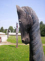
Horse sculpture

Stone sculpture for the battle of Mohács


literature
- Sátorhely - Településképi Arculati Kézikönyv 2017. Ed. By the municipal administration, Sátorhely 2017.
Web links
- Official website ( Hungarian )
- Mohácsi Nemzeti Emlékhely (Hungarian)
- Sátorhely község címere (Hungarian)